
Time zone EST (UTC−5) Area 176.3 km² Population 3,999 (2011) | Constituted January 1, 2000 Postal code(s) G0R 2C0 Local time Sunday 10:10 PM Province Québec | |
 | ||
Weather -3°C, Wind SE at 5 km/h, 73% Humidity | ||
L'Islet is a municipality within L'Islet Regional County Municipality in the Chaudière-Appalaches region of Quebec, Canada.
Map of L'Islet, QC, Canada
It is located on the south shore of the Saint Lawrence River halfway between Quebec City and Rivière-du-Loup. The Musée Maritime du Québec (Quebec Marine Museum) is located there on Route 132.
The current town of L'Islet was formed in 2000 with the merger of the former city of L'Islet, the municipality of L'Islet-sur-Mer and the parish municipality of Saint-Eugène.
Rivers include the:
The municipality got its name from a small island in the river near the village of L'Islet-sur-Mer.
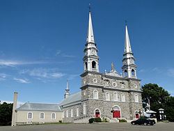
The Notre-Dame-de-Bonsecours church, built 1768, is an historical classified buildingest classée monument historique.
The town hosts many small events during the year such as Festival Guitares en fête, La Parades des Berlots and the L'Islet Car Show.