
Highest elevation 70 m (230 ft) Elevation 70 m | Area 4.8 ha (12 acres) Population 0 | |
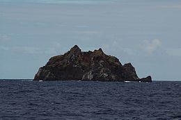 | ||
L'Esperance Rock, formerly French Rock, and previously Brind Rock (Named after William Brind), is the southernmost islet in the Kermadec Islands, to the north of New Zealand. It is 80 km (50 mi) south of Curtis Island and 600 km (370 mi) northeast of East Cape on New Zealand's North Island at 31°26′S 178°54′W. The smaller L'Havre Rock lies 8 km (5 mi) to the north-west of L'Esperance; it is a reef that barely reaches the surface. L'Esperance Rock is 250 m (820 ft) in diameter with an area of 4.8 ha (12 acres). It rises to a height of 70 m (230 ft).
Contents
Map of L'Esperance Rock
Important Bird Area
The island forms part of the Kermadec Islands Important Bird Area, identified as such by BirdLife International because it is an important site for nesting seabirds. It is the site of a substantial breeding colony of grey noddies. Masked boobies have also been recorded breeding there.