
- summer (DST) CEST (UTC+2) Area 26.41 km² | Elevation 358 m Local time Sunday 5:17 PM | |
 | ||
Weather 8°C, Wind W at 11 km/h, 39% Humidity Region krajs Žilina Region, Kysucké Nové Mesto District | ||
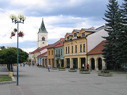
Kysucké Nové Mesto (German: Kischützneustadt / Oberneustadl; Hungarian: Kiszucaújhely) is a town in Žilina Region, Slovakia, near the city of Žilina.
Contents
- Map of KysuckC3A9 NovC3A9 Mesto Slovakia
- History
- Geography
- Demographics
- Twin towns Sister cities
- References
Map of Kysuck%C3%A9 Nov%C3%A9 Mesto, Slovakia
History
The first written record to the Kysuce region, which was relatively uninhabited at that time, was in 1244, and to the town in 1325 under name Congsberg. The inhabitants were living from agriculture, handicraft and trade.
Geography
Kysucké Nové Mesto lies at an altitude of 358 metres (1,175 ft) above sea level and covers an area of 26.414 square kilometres (10.199 sq mi). It is located in the Kysuca river valley, between the Javorníky and Kysucká vrchovina mountains, about 10 km (6.21 mi) north of Žilina.
Demographics
According to the 2001 census, the town had 16,558 inhabitants. 95.13% of inhabitants were Slovaks, 1.02% Czechs and 0.79% Roma and Germans. The religious make-up was 86.20% Roman Catholics, 6.79% people with no religious affiliation and 0.47% Lutherans.
Twin towns — Sister cities
Kysucké Nové Mesto is twinned with: