
Topo map 1320 II Eresfjord Prominence 210 m Parent range Romsdalsalpane | Elevation 1,439 m Mountain range Romsdalsalpane | |
 | ||
Similar Store Venjetinden, Juratinden, Romsdalshornet, Blånebba, Nonstinden | ||
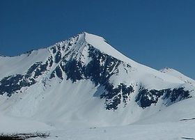
Kyrkjetaket or Kirketaket is a mountain on the border of the municipalities of Rauma and Nesset in Møre og Romsdal county, Norway. The peak is located in Rauma, about 7 kilometres (4.3 mi) northeast of the village of Isfjorden and 12.4 kilometres (7.7 mi) from Åndalsnes. The mountain Gjuratinden lies about 9 kilometres (5.6 mi) southeast of Kyrkjetaket. The name Kyrkjetaket translates to "the Church roof".
Map of Kyrkjetaket, 6320 Isfjorden, Norway
In February 2004 it was chosen as one of Norway's 10 finest alpine mountains by the magazine Fri Flyt.
References
Kyrkjetaket Wikipedia(Text) CC BY-SA