
Country Serbia Settlements 90 Time zone CET (UTC+1) Local time Sunday 8:01 AM | Elevation 366 m (1,201 ft) Area 952 km² | |
 | ||
Weather 12°C, Wind SW at 8 km/h, 69% Humidity | ||
Kuršumlija (Serbian Cyrillic: Куршумлија, [kurʃǔmlija]) is a town and municipality located in the Toplica District of the southern Serbia. It is situated near the rivers Toplica, Kosanica and Banjska, on the southeast of mount Kopaonik, and northwest of Mount Radan. As of 2011, the town has 13,306 inhabitants, while municipality has 19,213.
Contents
- Map of KurC5A1umlija Serbia
- Geography
- History
- Features
- Demographics
- Ethnic groups
- Notable natives or residents
- References
Map of Kur%C5%A1umlija, Serbia
Geography
Kuršumlija sits on the area of 952 km2 (367.57 sq mi) and administratively is in Toplica District. Its borders the municipalities of Brus, Blace, Prokuplje, Medveđa, Podujevo, and Leposavić. Its southwest border (105 km) is within the disputed territory of Kosovo.
History
The Romans established the Ad Fines military outpost in the 3rd century AD. There are also remains of churches from the Byzantine period. The Serbian principality of Rascia expanded from this region. Stefan Nemanja, a Serbian lord (župan), and the founder of Nemanjić dynasty, built his residence here, as well as the two monasteries of St Nicolas and the Holy Mother of God (before 1168).
There are many historical sights in Kuršumlija from that era: Mara Tower, Ivan Tower, and many medieval churches. The name in that period was Bele Crkve (White Churches) and Toplica. After the invasion by the Ottoman Empire in the 14th century, the Ottomans gave the town its current name, simply by translating the old name, Bele Crkve (White Churches). During Ottoman rule Kuršumlija was part of the Sanjak of Niš.
Toponyms such as Arbanaška and Đjake shows an Albanian presence in the Toplica and Southern Morava regions (located north-east of contemporary Kosovo) before the expulsion of Albanians during 1877–78 period.
The rural parts of Toplica valley and adjoining semi-mountainous interior was inhabited by compact Muslim Albanian population while Serbs in those areas lived near the river mouths and mountain slopes and both peoples inhabited other regions of the South Morava river basin.
As the wider Toplica region, Kuršumlija also had an Albanian majority. These Albanians were expelled by Serbian forces in a way that today would be characterized as ethnic cleansing.
In 1878, Kuršumlija became a part of the Principality of Serbia, which in 1882 became the Kingdom of Serbia. From 1929-41, Kuršumlija was part of the Morava Banovina of the Kingdom of Yugoslavia.
Features
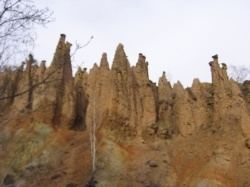
Kuršumlija is known for a natural monument of hoodoos near Mount Radan known as Đavolja Varoš ('Devil's Town'). There are three spas (banjas): the Prolom Banja, Kuršumlijska Banja, and Lukovska Banja. Prolom water is bottled at the Prolom Spa.
Demographics
The municipality of Kuršumlija includes one urban and 89 rural settlements. According to the 2011 census there are 19,213 inhabitants in the municipality.
Ethnic groups
Ethnic groups in the municipality: