
Location Sea of Okhotsk Length 123 kilometres (76 mi) Area 1,490 km² Island group Kuril Islands | Archipelago Kuril Islands Oblast Sakhalin Elevation 1,822 m Prefecture Hokkaido | |
 | ||
Width from 4 kilometres (2.5 mi) to 30 kilometres (19 mi) Highest point Tyatya
1,819 metres (5,968 ft) | ||
Kunashir Island (Russian: Кунаши́р; Japanese: 国後島, Kunashiri-tō; Ainu: クナシㇼ or クナシㇽ, Kunasir), possibly meaning Black Island or Grass Island in Ainu, is the southernmost island of the Kuril Islands, an archipelago currently under Russian control, among which four of (among them Kunashiri Island) are claimed by Japan (see Kuril Islands dispute).
Contents
Map of %E3%80%92694500 Kunashiri-to
It lies between the straits of Kunashir Island, Catherine, Izmena, and South Kuril. Kunashir Island is visible from the nearby Japanese island of Hokkaido, from which it is separated by the Nemuro Strait.
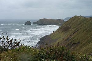
Kunashir Island is formed by four volcanoes which were separate islands but have since joined together by low-lying areas with lakes and hot springs. All these volcanoes are still active: Tyatya (1,819 m), Smirnov, Mendeleev (Rausu-yama), and Golovnin (Tomari-yama).
The island is made up of volcanic and crystalline rocks. The climate is humid continental with very heavy precipitation especially in the autumn and a strong seasonal lag with maximum temperatures in August and September. The vegetation mostly consists of spruce, pine, fir, and mixed deciduous forests with lianas and Kuril bamboo underbrush. The mountains are covered with birch and Siberian Dwarf Pine scrub, herbaceous flowers or bare rocks.
Tree cores of century-old oaks (Quercus crispula) were found in July 2001 on Kunashiri Island.
History
In 1789 Kunashir Island was one of the settings of the Menashi-Kunashiri Battle in which Ainu revolted against Japanese tradespeople and colonists.
Russian navigator Vasily Golovnin attempted to map and explore the island in 1811, but was apprehended by Japanese authorities and spent two years in prison.
On September 1, 1945, or one day before the surrender documents of World War II were signed on September 2, 1945, in accordance with decisions made at the Yalta Conference, the Soviet Union acquired the Kuril Islands. The Japanese government claims that the Northern Territories were not part of the Kuril Islands, due to historical reasons. This occurred after the Soviet Union renounced the Soviet–Japanese Neutrality Pact in April 1945 and declared war on Japan on August 9, 1945 (formally, the pact itself remained in effect until April 13, 1946).
Settlements
The largest settlement on Kunashir Island is Yuzhno-Kurilsk, administrative center of Yuzhno-Kurilsky District.
Economy
The primary economic activity is the fishing industry. The island has a port next to Yuzhno-Kurilsk.
Transport
The island is served by Mendeleyevo Airport.
Population
After the 1994 earthquake, about one-third of Kunashir Island's population left, and did not return. By 2002, the island's population was approximately 7,800. The total population of the disputed Kuril islands at that time was approximately 17,000.