
- left Shishi River Basin area 2,600 km² Basin area 26,000 km² Countries Afghanistan, Pakistan | - location Jalalabad Length 480 km Mouth Kabul River | |
 | ||
- right Lotkoh River, Landai Sin River, Pech River Provinces Khyber Pakhtunkhwa, Nuristan Province, Nangarhar Province | ||
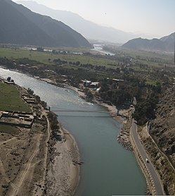
Eastern afghanistan kunar river
The Kunar River (Urdu,Pashto: کونړ سيند), also called the Chitral River (چترال سيند) or the Kama River (کامه سيند), is about 480 km long, located in northern Khyber Pakhtunkhwa, Pakistan, and eastern Afghanistan. The river system is fed by melting glaciers and snow of the Hindu Kush mountains. It is also part of the Indus watershed basin.
Contents
- Eastern afghanistan kunar river
- Map of Kunar
- Origin course of flow
- History
- Hydropower potential
- References
Map of Kunar
Origin & course of flow
The river rises in the far north glaciated Hindu Kush mountains of Chitral, Khyber Pakhtunkhwa, Pakistan. Downstream as far as Mastuj it is known as the Mastuj River from there to its confluence with the Lotkoh River just north of the important regional centre of Chitral. It is then called the Chitral River, before flowing south into the upper Kunar Valley of Afghanistan. At the confluence in Asadabad, historically Chaga Sarai, it meets with Pech River and finally empties into the Kabul River just to the east of the city of Jalalabad in Afghanistan. The combined rivers then flow eastwards into Pakistan again, roughly following the Grand Trunk Road through the Khyber Pass, and joining the Indus River at the city of Attock.
History
Before the political division of the area divided the Kunar and Chitral Valley between the modern nation states of Afghanistan and Pakistan, it had formed an important trade route, being the easiest way to travel from the Pamir Mountains' passes to the plains of the subcontinent. While navigable in parts by expert kayakers, etc..., it is more precise to say its valley forms a trade route since, like nearly all of the rivers in Africa and Asia, it is not navigable for commerce or transport.
"At about six miles from Jellalabad, we quitted the valley of the Cabul river, and entered that of the Kama or Kooner river. I have not seen so fine a valley as this anywhere. The Kama is a large rapid stream, with about a mile of rich soil on either side, sometimes considerably more. The villages are large and well peopled." - Major - General Augustus Abbott, mid 19th century
Hydropower potential
The river has great untapped hydropower potential which could be harnessed for cheap hydro electricity generation. Currently, under construction Golen Gol power project is also located on this river but its further development will lead the region on the path of progress.