
Time zone CET (UTC+1) Elevation 395 m Local time Sunday 3:33 AM | Website www.kuncicepo.cz Area 20.19 km² | |
 | ||
Weather 2°C, Wind W at 10 km/h, 76% Humidity | ||
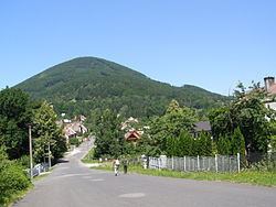
Kunčice pod Ondřejníkem is a village in Frýdek-Místek District, Moravian-Silesian Region, Czech Republic. It had an estimated population of 2,004 in 2006. There is an 18th-century wooden church in the village. It was relocated here in 1931 from the Subcarpathian Rus. Kunčice pod Ondřejníkem lies in the Moravian-Silesian Beskids and is a popular spot for tourists.
Contents
- Map of KunC48Dice pod OndC599ejnC3ADkem Czechia
- Agentura 7 t bor kun ice pod ond ejn kem promo
- References
Map of Kun%C4%8Dice pod Ond%C5%99ejn%C3%ADkem, Czechia
Agentura 7 t bor kun ice pod ond ejn kem promo
References
Kunčice pod Ondřejníkem Wikipedia(Text) CC BY-SA