
Time zone EET (UTC+2) Licence plate 45 Elevation 665 m Local time Saturday 11:58 PM | Region Aegean Postal code 45xxx Website www.kula.bel.tr Area 918 km² Area code 236 | |
 | ||
Weather 3°C, Wind SE at 5 km/h, 63% Humidity | ||
Kula is a town and district of Manisa Province in the Aegean region of Turkey. According to the 2000 census, population of the district is 52,986 of which 24,217 live in the town of Kula. The district covers an area of 918 km2 (354 sq mi), and the town lies at an elevation of 665 m (2,182 ft).
Contents
Map of Kula, 45170 Kula%2FManisa, Turkey
Economy
As of 1920, Kula's main industry was carpet making.
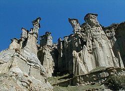
Yanıkyöre volcanic rock formations
The district is renowned for the cone-shaped volcanic rock formations, numbering at about eighty, in the nearby Yanıkyöre (literally the burnt land) area, also sometimes still referred to, including in Turkey, under the Greek name of Katakekaumene, which has the same meaning. Increasingly brought to the attention of a wider public in recent years as a natural curiosity, other recently coined terms to describe the area include "Cappadocia of the Aegean Region, Turkey" or even "Kuladocia".
Kula Volcanic Geopark was accepted and certificated by UNESCO on 6 September 2013 at 37th UNESCO general conference in Naples. So that Kula Volcanic Geopark joined UNESCO Global Geopark Network. Also this patent became the first geopark of Turkey, 58th geopark in Europe, and 96th geopark in the world.