
Elevation 2,086 m | Prominence 1,156 m | |
 | ||
Mountain type Oberrät Limestone in the summit region , otherwise Main Dolomite Normal route Partenkirchen – Esterberg Alm – Weilheimer Hut – Krottenkopf Similar Hohe Kisten, Hoher Fricken, Bischof, Simetsberg, Wank | ||
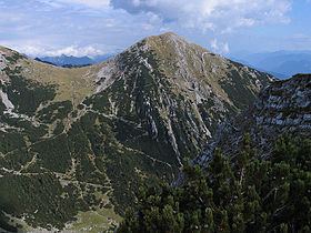
The Krottenkopf ( [ˈkʁɔtənˌkɔpf]), 2,086 metres/6,844 ft, is a peak in the Ester Mountains and the highest mountain in the Bavarian Prealps. It lies within the Bavarian district of Garmisch-Partenkirchen.
Contents
Map of Krottenkopf, 82438 Eschenlohe, Germany
Location and climbing optionsEdit
It lies in the westernmost part of the Bavarian Prealps in the Ester Mountains near the town of Garmisch-Partenkirchen. Immediately below and a half an hour from the summit is the Weilheimer Hut (1,955 metres/6,414 ft), the highest Alpine Club hut in the Bavarian Prealps.
There are four climbing options:
References
Krottenkopf Wikipedia(Text) CC BY-SA