
Time zone CET/CEST (UTC+1/+2) Area 32.13 km² Postal code 06895 Dialling code 034920 | Elevation 107 m (351 ft) Postal codes 06895 Local time Saturday 12:28 PM | |
 | ||
Weather 11°C, Wind W at 32 km/h, 79% Humidity | ||
Kropstädt is a village and a former municipality in Wittenberg district in Saxony-Anhalt, Germany. Since 1 January 2010, it is part of the town Wittenberg.
Contents
- Map of KropstC3A4dt Germany
- Kropst dt stadt lutherstadt wittenberg sachsen anhalt 8 8 2013
- Geography
- Economy and transportation
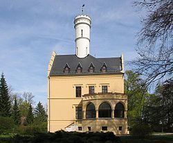
- Sights
- Personalities
- References
Map of Kropst%C3%A4dt, Germany
Kropst dt stadt lutherstadt wittenberg sachsen anhalt 8 8 2013
Geography
Kropstädt lies about 12 km northeast of Lutherstadt Wittenberg in the Fläming and is part of the Fläming Nature Park, which was opened in 2005.
Economy and transportation
Federal Highway (Bundesstraße) B 2 from Wittenberg to Berlin runs right through the community.
Sights
Personalities
References
Kropstädt Wikipedia(Text) CC BY-SA