
- left Karnmelkspruit - location Moshesh's Ford - elevation 1,340 m (4,396 ft) | - elevation 1,845 m (6,053 ft) | |
 | ||
- location Aliwal North, Eastern Cape, South Africa | ||
The Kraai River ("Crow River") is a tributary of the Orange or Gariep River that flows near Barkly East in the Eastern Cape, South Africa.
Contents
Map of Kraairivier, South Africa
The Kraai River originates in the mountains south of Lesotho and flows westward from the confluence of the Bell River and the Sterkspruit at Moshesh's Ford at 30°51′09″S 27°46′40″E all the way to Aliwal North, where it joins the Orange River at 30°40′02″S 26°45′06″E.
The river flows almost entirely over sandstone rocks of the Clarens Formation.
The Kraai is fishable, containing Rainbow Trout, Brown Trout and Smallmouth Yellowfish.
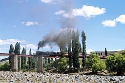
In 1881 a sandstone arch bridge called the J W Sauer bridge was completed over the river. The bridge linked communities in the Kraai River basin with Aliwal North. The Sauer bridge and the Loch Bridge on the farm Tyger Krantz, are now Provincial Heritage sites.