
District Tuttlingen River system Danube Length 16 km Source Tuningen Country Germany | Progression Danube → Black Sea Basin size 33.2 km (12.8 sq mi) Basin area 33.2 km² Mouth Danube | |
 | ||
Main source About 200 m (660 ft) east of the clay pit in the Haldenwald forest in Tuningen
806 m (2,644 ft) River mouth Confluence with Danube at Tuttlingen-Möhringen
644 m (2,113 ft) | ||
The Krähenbach is a tributary of the Danube on the Baar plateau in Tuttlingen in the Upper Danube Nature Park .
Contents
Map of Kr%C3%A4henbach, Tuttlingen, Germany
Course
The Krähenbach rises some 200 m east of the clay pit in the Haldenwald forest in the municipality of Tuningen, next to a forest road at about 806 m above sea level (NN). From there it flows northeast through the Haldenwald forest past a Celtic square earthwork, underneath the Federal Road B523 and then across the fen into the municipality of Talheim. Here is reaches its norhternmost point, a sharp turn to the southeast. Next to the K5919, it leaves its narrow valley and takes up the Zimmerthälebach from the right, and, less than 200m further, the Krähenbach the Greutgraben form the left. It then flows past two small lakes, the second of which is used as a swimming pool. If then takes up the Lachengraben from the right and flows through the village of Talheim. It then takes up the Röhrenbrunnenbach from the right, then turns to the east.
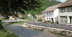
At the Upper Mill outside the village of Weichbild, the direction changes back to southeast. Here, the stream is accompanied by the K5944 and the B523 on the right bank. It flows through a valley with wooded slopes, past the Götzenloch court on the left and the Lower Mill on the right, below the ruins of Klingenberg Castle. Past mount Reisenberg, the B523 changes to the left bank. The Krähenbach then flows past mount Sommerbergs and takes up some minor tributaries on both sides, before flowing into the village Eßlingen in the municipality of Tuttlingen, which is the seat of the eponymous Landkreis. Some of the water is diverted into a several kilometers long mill stream, which rejoins the Krähenbach before Eßlingen Mill, right below a pass across which the B523 continues into the adjacant Elta valley. A this point, the distance between the Krähenbach and the Elta is slightly more than 600 meters.
The Tiefentalbach flows down from mount Möhringer Berg through a wooded valley and joins the Krähenbach from the right, opposite Eßlingen Mill, which is situated below the ruins of Konzenberg Castle. Further downstream, a reservoir fills almost the entire width of the valley. The Krähenbach flows to the right of this reservoir and on through the Bächetal valley. After a recent nature restoration project, the Krähenbach is once again able to meander through this valley. It then reaches the northern edge of the village of Möhringen an der Donau. This village is now part of Tuttlingen and lies in the floodplain on the left side of the Danube. Inside Möhringen, the Krähenbach takes up a stream coming down from the Kühltal valley on the right.
In summer, when all of the water of the upper Danube disappears into the Danube Sinkhole, the Krähenbach is the first river to provide water to the dry Danube bed.
Tributaries
Catchment area
The catchment area of the Krähenbach measures 33.3 km². It borders on the left side to the north and northwest to that of the Elta, on the south by that of the Weißenbach, on the west briefly to that of Amtenhauser Bach, in the north-west of the Kötach, all of which also flow to the southeast to the upper Danube.