
- summer (DST) CEST (UTC+2) Area 23.81 km² | Elevation 130 m Local time Saturday 4:18 PM | |
 | ||
Weather 8°C, Wind SW at 16 km/h, 84% Humidity | ||
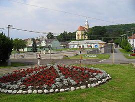
Kráľovský Chlmec (until 1948 Kráľovský Chlumec, Hungarian: Királyhelmec) is a town in the Trebišov District in the Košice Region of south-eastern Slovakia. As of 2005, it had a population of 7,938.
Contents
- Map of 077 01 KrC3A1C4BEovskC3BD Chlmec Slovakia
- Etymology
- History
- Geography
- Demographics
- Education
- Notable people
- Partner towns
- References
Map of 077 01 Kr%C3%A1%C4%BEovsk%C3%BD Chlmec, Slovakia
Etymology
The name means "Royal Hill". Slovak chlm, Czech chlum, Polish chełm are derived from a Proto-Slavic chъlmъ - a hill, chlmec - a smaller hill, an elevated location.
History
The town was first mentioned in 1214 as Helmech. After the break-up of Austria-Hungary and 1918 partitioning of Kingdom of Hungary in the Treaty of Trianon, the town was awarded to Czechoslovakia. It was annexed again by Hungary from 1938 to 1945 as a result of controversial First Vienna Award.
Geography
Kráľovský Chlmec lies at an altitude of 130 metres (427 ft) above sea level and covers an area of 23.08 square kilometres (8.9 sq mi). It is located in the southern part of the Eastern Slovak Lowland, only around 5 kilometres (3 mi) north of Hungarian and 12 kilometres (7 mi) west of Ukrainian border. The regional capital Košice is 90 kilometres (56 mi) away.
Demographics
According to the 2001 census, the town had 8,031 inhabitants. 76.94% of inhabitants were Hungarians, 18.86% Slovaks, 3.26% Roma and 0.37% Czechs.
Education
Gymnázium Kráľovský Chlmec The Royal Grammar School Chlmec opened in 1949. (Gimnazium (HUN) = High School)