
Elevation 185 m | Area 21.82 km² | |
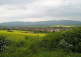 | ||
Kozárovce (Hungarian: Garamkovácsi) is an old village and municipality in the Levice District in the Nitra Region of Slovakia.
Contents
Map of Koz%C3%A1rovce, Slovakia
History
In historical records the village was first mentioned in 1075.
Geography
The village lies at an altitude of 185 metres and covers an area of 21.822 km². It has a population of about 2,022 people.
Demographics
The village is approximately 94% Slovak 5% Romani and almost 1% Hungarian.
Government
The village has its own birth registry.
Facilities
The village has a public library a gym, swimming pool and soccer pitch. It also has a cinema.
References
Kozárovce Wikipedia(Text) CC BY-SA