
Alternate name Curium | Type Settlement | |
 | ||
Management Cyprus Department of Antiquities Weather 12°C, Wind W at 18 km/h, 63% Humidity Points of interest Kourion, Κourion Ancient Amphitheater, Triclinium Of The Early Chri | ||
Kourion cyprus vacation travel video guide
Kourion (Greek: Κούριον) or Latin: Curium, was an ancient city on the southwestern coast of Cyprus, the surrounding Kouris River Valley being occupied from at least the Ceramic Neolithic period (4500-3800 BCE) to the present. The acropolis of Kourion, located 1.3 km southwest of Episkopi and 13 km west of Limassol, is located atop a limestone promontory nearly one hundred meters in height along the coast of Episkopi Bay. The Kourion archaeological area lies within the Akrotiri West Sovereign Base Area, which forms part of the British Overseas Territory of Akrotiri and Dhekelia. The Kourion Archaeological Area, and all antiquities within the Akrotiri West Sovereign Base are managed by the Cyprus Department of Antiquity. Kourion is a listed UNESCO World Heritage Site.
Contents
- Kourion cyprus vacation travel video guide
- Map of Ancient Kourion Episkopi Cyprus
- Ancient kourion amphitheater trip cyprus
- History of Kourion
- History of excavations
- Archaeological remains
- The Sanctuary of Apollo Hylates
- The Theatre
- House of Achilles
- House of the Gladiators
- The Forum the Nymphaeum and the Forum Baths
- The Stadium
- The Baths and House of Eustolios
- Episcopal Precinct and Cathedral of Kourion
- The Northwestern Basilica
- The Early Christian Harbor Basilica
- Paragliding
- References
Map of Ancient Kourion, Episkopi, Cyprus
Kourion was an urban center of considerable importance within Cyprus, reaching the climax of its influence in the Roman and Late Roman periods. The city is mentioned by several ancient authors including: Ptolemy (v. 14. § 2), Stephanus of Byzantium, Hierocles, and Pliny the Elder. Though Kourion attained its highest prominence under the Romans, the Kouris River Valley has seen occupation from the Ceramic Neolithic period to the present village of Episkopi. Occupation on the acropolis appears to have been from the Late Classical period at latest until the Arab raids of the 7th century CE.
Ancient kourion amphitheater trip cyprus
History of Kourion
The earliest occupation within the Kouris Valley is the hilltop settlement of Sotira-Teppes, located 9 km northwest of Kourion. This settlement dates to the Ceramic Neolithic period (circa 5500 – 4000 BCE). Another Ceramic Neolithic hilltop settlement has been excavated at Kandou-Koupovounos, another hilltop situated along the east bank of the Kouris River. In the Chalcolithic period (3800–2300 BCE) settlement shifted to the site of Erimi-Pamboules, located within the limits of the village of Erimi. Erimi-Pamboules was occupied from the conclusion of the Ceramic Neolithic through the Chalcolithic period (3400–2800 BCE).
Occupation of the Early Cypriot period (circa 2300–1900 BCE) is uninterrupted from the preceding Chalcolithic period, with occupation continuing along the Kouris River Valley and the drainages to the west. Sotira-Kaminoudhia, located to the northwest of Sotira-Teppes, on the lower slope of the hill, was settled. It dates from the Late Chalcolithic to EC (Early Cypriot) I (ca .2400 – 2175 BCE). In the ECIII-LC (Late Cypriot) IA (ca. 2400 – 1550 BCE) a settlement was established 0.8 km east of Episkopi at Episkopi-Phaneromeni. The Middle Cypriot (1900–1600 BCE) is a transitional period in the Kouris River Valley. The settlements established during the MC flourished into urban centers in the Late Cypriot II-III, especially Episkopi-Bamboula.
In the Late Cypriot I-III (1600–1050 BCE) the settlements of the Middle Cypriot period developed into complex urban center within the Kouris Valley, which provided a corridor in the trade of Troodos copper, controlled through Alassa and Episkopi-Bamboula. In the MCIII-LC IA a settlement was occupied at Episkopi-Phaneromeni. Episkopi-Bamboula, located on a low hill 0.4 km west of the Kouris and east of Episkopi, was an influential urban center from the LC IA-LCIII. The town flourished in the 13th century BCE before being abandoned c.1050 BCE. In the Cypro-Geometric (1050-750 BCE)the Kingdom of Kourion was established, though the occupational center remains unidentified.
In the Cypro-Archaic period (750–475 BCE) the Kingdom of Kourion was among the most influential kingdoms of Cyprus. In 672 Damasos, king of Kourion, is recorded as a tributary of Esarhaddon of Assyria as Damasu of Kuri. Between 569 and ca. 546 BCE Cyprus was under Egyptian administration. In 546 BCE Cyrus I of Persia extended Persian authority over the Kingdoms of Cyprus, including the Kingdom of Kourion. During the Ionian Revolt (499–493 BCE), Stasanor, king of Kourion, aligned himself with Onesilos, king of Salamis, the leader of a Cypriot alliance against the Persians. In 497 Stasanor betrayed Onesilos in battle against the Persian general Artybius, resulting in a Persian victory over the Cypriot poleis and the consolidation of Persian control of Cyprus.
In the Classical Period (475–333 BCE) the earliest occupation of the acropolis was established, though the primary site of settlement is unknown. King Pasikrates of Kourion is recorded as having aided Alexander the Great in the siege of Tyre in 332 BCE. Pasikrates ruled as a vassal of Alexander but was deposed in the struggles for succession amongst the diadochi. In 294 BCE the Ptolemies consolidated control of Cyprus, and Kourion came under Ptolemaic governance.
In 58 BCE the Council of the Plebs (Consilium Plebis) passed the Lex Clodia de Cyprus, annexing Cyprus to the province of Cilicia and bringing it under Roman rule. Between 47 and 31 BCE, Cyprus was returned to Ptolemaic rule under Marc Antony and Cleopatra VII, reverting to Roman rule after the defeat of Antony. In 22 BCE, Cyprus was separated from the province of Cilicia, being established as a Senatorial province under a proconsul. In the Roman period, Kourion was among the most prominent cities of the Cyprus, the Sanctuary of Apollo Hylates being a Pan-Cypriot sanctuary alongside the Temple of Zeus Salaminos at Salamis and Aphrodite at Kata Paphos.
In the mid-1st century Christianity was introduced to Kourion, presumably by Saints Paul and Barnabas during Paul's first missionary journey. During the persecutions of Diocletian, Philoneides, the Bishop of Kourion, was martyred. In 341 CE,the Bishop Zeno was instrumental in the Council of Ephesus in asserting the independence of the Cypriot church.
In the later-4th century (c. 365/70) Kourion have been hit by five strong earthquakes within a period of eighty years, as can be seen by the archaeological remains throughout the site, and suffered a total destruction. In the early-5th century Kourion was reconstructed, the reconstruction including the construction of the ecclesiastical complex on the western side of the acropolis. In 649 the Arab raids resulted in the destruction of the acropolis, after which the center of occupation was relocated to Episkopi, 2.0 km northeast of the acropolis. Episkopi was named for the seat of the Bishop (Episcopus).
History of excavations
The site of Kourion was identified in the 1820s by Carlo Vidua. In 1839 and 1849, respectively, Lorenzo Pease and Ludwig Ross identified the Sanctuary of Apollo Hylates to the west of the acropolis. In 1874–5, Luigi Palma di Cesnola, then American and Russian consul to the Ottoman government of Cyprus, extensively looted the cemetery of Ayios Ermoyenis and the Sanctuary of Apollo Hylates. Between 1882 and 1887 several unauthorized private excavations were conducted prior to their illegalization by British High Commissioner, Sir Henry Bulwer in 1887.
In 1895 the British Museum conducted the first quasi-systematic excavations at Kourion as part of the Turner Bequest Excavations. P. Dikaios of the Department of Antiquities conducted excavations in the Kaloriziki Cemetery in 1933.
Between 1934 and 1954, G. McFadden, B.H. Hill and J. Daniel conducted systematic excavations at Kourion for the University Museum at the University of Pennsylvania. Following the death of G. McFadden in 1953, the project and its publication stalled. The excavations of the Early Christian Basilica on the acropolis were continued by A.H.S. Megaw from 1974–9.
The Cyprus Department of Antiquities has conducted numerous excavations at Kourion including: M. Loulloupis (1964–74), A. Chritodoulou (1971–74), and D. Christou (1975–1998). Between 1978 and 1984 D. Soren conducted excavations at the Sanctuary of Apollo Hylates, and on the acropolis between 1984 and 1987. D. Parks directed excavations within the Amathus Gate Cemetery between 1995 and 2000. The 'Amathus Gate' cemetery was excavated by D. Parks between 1995 and 2000.
Since 2012 the Kourion Urban Space Project, under the direction of T.W. Davis of the Charles D. Tandy Institute of Archaeology, has excavated on the acropolis.
Archaeological remains
The majority of the archaeological remains within the Kourion Archaeological Area date to the Roman and Late Roman/Early Byzantine periods. The acropolis and all archaeological remains within the area are managed and administered by the Cyprus Department of Antiquities and are listed as a UNESCO World Heritage Site.
The Sanctuary of Apollo Hylates
The Sanctuary of Apollo Hylates, located 1.7 km west of the acropolis, was a Pan-Cypriot sanctuary, third in importance only to the Sanctuaries of Zeus Salaminos and Paphian Aphrodite. The earliest archaeological evidence indicates that the sanctuary was established in the late-8th century BCE, the sanctuary being dedicated to "the God," apparently unassociated with Apollo. By the mid-3rd century BCE, the sanctuary was dedicated to Apollo Hylates. The sanctuary at present was constructed in the 1st century and early 2nd century. The temple was abandoned in the late-4th century.
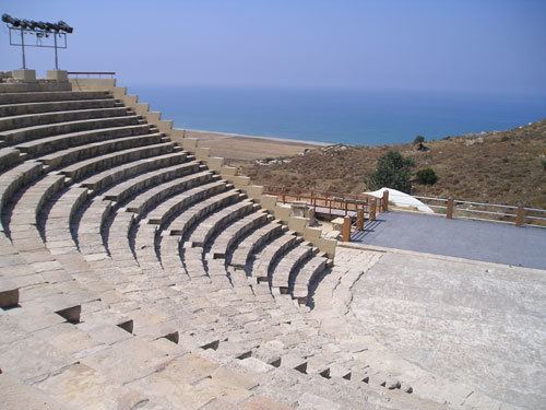
The Theatre
The theatre of Kourion was excavated by the University Museum Expedition of the University of Pennsylvania between 1935 and 1950. The theatre was constructed into the northern slope of the defile descending to the Amathus Gate, thus utilizing the slope of the hill to partially support the weight of the seating in the cavea. This architectural arrangement in typical throughout theatres of the Eastern Mediterranean. The theatre was initially constructed on a smaller scale in the late-second century BCE. The theatre was repaired in the late-first centiry BCE, likely following the earthquake of 15 BCE. The theatre's stage was seemingly reconstructed in 64/65 CE by Quintus Iulius Cordus, the proconsul. The theatre received an extensive renovation and enlargement under Trajan in 111 CE, bringing the theatre to its presently preserved extent. Between 214 and 217 CE, the theatre was modified to accommodate gladiatorial games and venationes but it was restored to its original form as a theatre after 250 CE. The theatre was abandoned in the later-fourth century CE, likely the result of successive seismic events, the earthquake of 365/70 perhaps resulting in its abandonment. The enlarged cavea of the Roman phases could have accommodated an audience of as many as 3,500. The stage building (scaenae frons) is preserved only in its foundations, though this would have originally obscured the view of the Mediterranean to the south. The present remains of the theatre have been restored extensively. The theatre is one of the venues for the International Festival of Ancient Greek Drama.
House of Achilles
The House of Achilles, located at the northwestern extent of the acropolis, at the southern end of a saddle connecting the acropoline promontory to the hills to the north and west. It was located outside the walls, which has been partially exposed immediately to the south, and near the proposed site of the Paphos Gate.
The House of Achilles was constructed in the early-fourth century CE. The structure is arrayed around a central peristyle courtyard with fragmentarily preserved mosaic pavements in the northeastern portico. The most important mosaic depicts the unveiling of Achilles’ identity by Odysseus in the court of Lycomedes of Skyros when his mother, Thetis, had hidden him there amongst the women so that he might not be sent to war against the Trojans. In another room, a mosaic depicting Thetis bathing Achilles for the first time has been fragmentarily preserved. In yet another room a fragmentary mosaic depicts the Rape of Ganymede. Though it has been tentatively identified as a private-house, it may have functioned as a public reception hall.
House of the Gladiators
The so-called House of the Gladiators is located south and east of the House of Achilles. The structure dates to the late-third century CE. The structure has been interpreted as an elite-private residence, or perhaps more probably as a public palaestra. The later identification is supported by the absence of many rooms appropriate for living spaces and that the structure was entered from the east through the attached bath complex. The main wing of the structure is arranged around a central peristyle courtyard, the northern and eastern porticos of which possess preserved mosaic pavements depicting gladiatorial combats. The eastern portico of the atrium contains two panels depicting gladiators in combat, the only such mosaics in Cyprus.
The Forum, the Nymphaeum and the Forum Baths
The forum of Kourion was constructed in the late-2nd or early-3rd centuries, an constituted the center of Kourion's public life. The forum consisted of a central pavement with colonnaded porticoes set along its east, north and southern sides. The eastern portico measured 65m in length and 4.5 m wide, with a colonnade facing the courtyard, and a wall forming frontage of shops to the west. The northern portico provided access to a monumnetal nymphaeum and a bath complex thermae constructed around the nymphaeum. The nymphaeum, measuring 45x15m was constructed in 1st century and renovated during the reign of Trajan (98–117) at which time the baths were constructed around it, along the northern side of the agora.
The Forum Baths, constructed on the east and west of the nymphaeum, and north and northeast of the forum, were constructed in the early-4th century following the final renovation of the nymphaeum. The baths were divided into east and west wings by the nymphaeum. The eastern baths were arranged around a central corridor which opened onto a sudatorium, a caldarium, and a tepidarium to the north. The western baths possessed a series of axially aligned baths along the northwest wall of the nymphaeum.
The forum, the nymphaeum, and the baths destroyed in the earthquakes of the mid-4th century and were subsequently reoccupied. The nymphaeum was reconstructed as a three-aisled basilica, with apses along the south wall. It was temporarily used as a church between c.370 and 410 during the construction of the nearby episcopal precinct. In the early-5th century the western portico was renovated to allow an entrance to the ecclesiastical precinct to the west. The structural elements of the porticoes were extensively reused in the construction of the episcopal precinct.
The Stadium
The stadium of Kourion, located 0.5 km west of the acropolis and 1.1 km east of the Sanctuary of Apollo Hylates, was constructed during the Antonine period (c. 138–180). The stadia of Kourion was 187m in length with a starting line marked by two circular stone posts, set wide enough to accommodate eight runners. The free-standing curved seating structure enclosed the dromos on its south, west and north sides and measured 217 m long and 17 m wide. In its entirety the stadium measured 229 m in length and 24 m in width. This structure consisted of seven rows of seating supported by a 6-m-thick ashlar wall. Seating was probably accessed by stairs set at 10m intervals along the exterior of the structure. The dromos was accessed by gaps in the structure in the middle of the north and south sides, and at the center of its curved western end. This structure provided sufficient seating for approximately 6,000 spectators. The stadium was abandoned in later-half of the 4th century. It remains the only excavated stadium in Cyprus.
The Baths and House of Eustolios
The House and Baths of Eustolios, situated on the crest of the southern cliffs immediately above the theatre, was constructed in the late-4th century over the remains of a structure destroyed in the mid-4th century. In the early years of the 5th century, seemingly immediately after the completion of the house, a bathing complex was constructed along the northern side of the house. The household and bath annex on the northern side contains more than thirty rooms. The complex was entered from the west, the visitor passing into a rectangular forecourt. A salutatory inscription in the vestibule beyond the forecourt reads, "Enter for the good luck of the house." Rooms were arranged north and south of this forecourt and the vestibule, including a peristyle courtyard to the south at its eastern extent. The southern peristyle was arranged around a central pool and is the centerpiece of the household, its porticoes adorned with elaborate mosaics. A mosaic inscription in the eastern portico identifies the building as Eustolios, who built the structure to alleviate the suffering of the populace of Kourion, presumably in response to the earthquakes of the mid-to-late 4th century. The inscription identifies Eustolios as a Christian, concluding, “this house is girt by the much venerated signs of Christ.” The accompanying iconography includes figural depictions of fish and birds (grey goose, guinea hen, falcon, partridge and pheasant).
The bathing complex is arranged around a central rectangular hall and included a frigidarium with an antechamber, a tepidarium, and a caldarium. The frigidarium is paved with a figural mosaic depicting a personification of Ktisis (Creation) holding an architect's ruler. The complex remained in use until its destruction in the mid-7th century. The household was probably constructed as an private elite-residence, but was converted into a publicly-accessible bathing facility in the early-fifth century.
Episcopal Precinct and Cathedral of Kourion
The episcopal precinct of Kourion, located along the crest of the cliffs immediately southwest of the forum, was constructed at the beginning of the 5th century and renovated successively in the 6th century CE. This monoapsidal, three-aisled basilica, constructed on an east-west orientation, comprised the seat (cathedra) of the Bishop of Kourion. The aisles were separated from the nave by colonnades of twelve columns set on plinths. The central nave's eastern terminus ended in a semicircular hemidomed apse with a synthronon. The basilica was magnificently appointed according to its importance within the ecclesiastical structure of Cypriot Christianity. The walls were revetted in white marble. The eastern extent of the aisles allowed access to sacristies. The altar was enclosed within a chancel screen, and covered within a four-posted baldachin. The aisles were paved in opus sectile while the nave was paved with polychrome mosaics. The complex included a barthex arrayed along the facade of the basilica and a peristyle atria arrayed both west and north of the narthex. This northern atrium provided access alternately to the episcopal palace to its west or to the baptistery to the east, situated north of the basilica along with a diakoinon and cathechumena. The precinct was destroyed during the Arab raids of the 7th century, after which the seat of the Bishop of Kourion was moved inland where the village of Episkopi was established.
The Northwestern Basilica
In the late-5th century, a Christian tri-apsidal, three-aisled basilica was constructed on the height northwest of the acropolis on the northern side of the road between the acropolis to the southeast and the Sanctuary of Apollo Hylates. In Classical antiquity this site may have been a sanctuary dedicated to Demeter and Kore, as evidenced by a dedicatory inscription found on the site. The basilica was constructed on an easterly orientation. The central nave and aisles were paved with marble slabs. The central apse possessed a synthronon for the clergy, with the chancel set apart from the nave by marble screens and an opus sectile pavement. The basilica was accessed through a colonnaded peristyle courtyard and narthex west of the basilica. This atrium was entered from the north and south. The peristyle courtyard was centered upon a rectangular cistern. Also accessed off the narthex and atrium were two catechumenon, flanking the basilica to the north and south, and a diakoinon to the north. The basilica was abandoned during the Arab raids of the mid-7th century.
The Early Christian Harbor Basilica
In the early-6th century, an early Christian basilica was constructed at the base of the southwestern bluffs, below the acropolis, near the western extent of the unexcavated harbor area. The church was a tri-apsidal, three-aisled basilica that measured approximately 27.5 m in length and 14 m in width on its exterior. It was oriented with the altar facing southeast. The central nave measured approximately 25 m including the apse, and 5.5 m wide, with the flanking aisles being 2.75 m in width. The colonnades supporting the clerestory ceiling of the nave consisted of six corinthian columns. The eastern ends of the aisles and nave terminated in half-domes adorned with mosaics. The chancel was paved with opus sectile while the nave and aisles were paved in mosaics. A peristyle atrium was arrayed west of the basilica, with a baptistery opening off the northern portico, and access to the basilica complex being controlled through the southern portico. The peristyle courtyard was centered upon a well. A catechumena was arrayed along the southern aisle of the basilica and was accessed from the southeast corner of the atrium. The basilica was abandoned in the mid-7th century, a date likely correlating to the earliest Arab raids on coastal Cypriot cities.
Paragliding
Kourion is a major paragliding site in Cyprus and is flyable on most days of the year. Many pilots from all over Cyprus and visitors to the island use the area as a launching spot.