
Country Congo | ||
 | ||
The Kouilou-Niari River — also spelled Kwilu, Kwila, or Kwil — is the most important river flowing to the Atlantic Ocean of the Republic of the Congo coast. Moreover, it entire drainage area is completely in the Republic of the Congo. The river is called the Kouilou River while flowing in the coastal region of the Kouilou till the Sounda gorges. Upstream from the Gorges, its name is the Niari and it flows through the Niari Valley. The river combines with the Louessé River, the Loudima and the Bouenza and eventually flows into the Atlantic Ocean. It covers about 560 km from its origin in the plateaux batéké of The Congo to its mouth at the coast.
Contents
Map of Kouilou River, Republic of the Congo
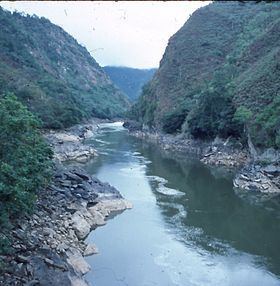
The river has numerous waterfalls and is impassable from its mouth, which is of difficult access by multiple sandbars, formed primarily by the action of the Benguela current. The River is usable and boats are coming up to Kakamoéka. From Kakamoéka to Sounda, rapids and rocks are blocking access especially during dry season. Very limited Traffic upstream Sounda as they are rapids and a few bridges.
Bridges on the River are located at Bas-Kouilou, Sounda, Kimbangou, Makabana, Loudima and Bouenza.
The Kouilou part is fairly flat with the water level rising only 16 meters above Sea level on first 70 km. In the area of Kimbangou, the water level is around 60 meters above sea level and reaches 115 meters at the Loudima junction.
List of waterfalls
The gorges are remarkable with a small waterdrop of 2 meters and mountain around 120 meters high. An old iron bridge is still usable in 2012 to cross the river in Sounda. A road comes from the village of Mandzi south of Sounda while the road continues on north west toward Kakamoéka, sous-prefectuure. An abandoned track on the southern bank of the river reaches Kakamoéka which was created during the exploration for the train. The mission Jacob was conducted in 1896. The track wad reopened in 1954 for the evaluation of the hydro potential of the Sounda dam.
In Sounda, a large Hydro electrical project has been evaluated since the mid 50's when France was looking at developing the region. 10 years of research have led to a tunnel built in the mountain, a bridge and a camp established on site.
In May 2011, a protocole d'accord has been signed with a South African Company IDG and the Republic of Congo for the development of the Sounda dam project. IDG has teamed up with strategic partner African Power Corporation (APC). The 2 companies have joined forces to lead the development of the project. Coming together with the potential users and financial institution to put the project on track for success. Such a project is expected to help develop the country's huge mineral potential. In October 2012, APC increased their presence in the country and name a country representative. Nicolas Rouzé has a great experience in the Congo as he has been in country since 1998. He is managing the efforts in Country to drive the project on the local scale.
Annex
Nicolas Tourot, Les Projets de développement hydroélectrique en Afrique noire, mémoire de maîtrise, Paris I,2003 EDF, études préliminaires du site hydroelectrique de Sounda, 1954.