
Elevation 219 m Local time Friday 7:08 PM | Region Ústí nad Labem Postal code 413 01 Area 7.89 km² | |
 | ||
Weather 10°C, Wind NW at 16 km/h, 65% Humidity | ||
Phl ctin ves 5 7 2016 kostomlaty pod pem p
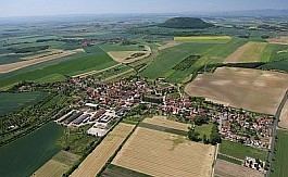
Kostomlaty pod Řípem is a village and municipality (obec) in Litoměřice District in the Ústí nad Labem Region of the Czech Republic.
Contents
- Phl ctin ves 5 7 2016 kostomlaty pod pem p
- Map of 413 01 Kostomlaty pod C598C3ADpem Czechia
- Phl ctin ves 5 7 2016 kostomlaty pod pem top
- References
Map of 413 01 Kostomlaty pod %C5%98%C3%ADpem, Czechia
The municipality covers an area of 7.89 square kilometres (3.05 sq mi), and has a population of 458 (as at 28 February 2009).
Kostomlaty pod Řípem lies approximately 24 kilometres (15 mi) south-east of Litoměřice, 38 km (24 mi) south-east of Ústí nad Labem, and 33 km (21 mi) north of Prague.
Phl ctin ves 5 7 2016 kostomlaty pod pem top
References
Kostomlaty pod Řípem Wikipedia(Text) CC BY-SA