
Founded January 15, 1851 Website www.co.kossuth.ia.us Population 15,321 (2013) | Area 2,523 km² Unemployment rate 2.8% (Apr 2015) | |
 | ||
Cities Points of interest Lake Smith Park, Camp Algona POW Mus, Kossuth County Agricultur, Union Slough National, Ambrose A Call State Park | ||
Kossuth County is a county in the U.S. state of Iowa. As of the 2010 census, the population was 15,543. The county seat is Algona.
Contents
- Map of Kossuth County IA USA
- History
- Geography
- Major highways
- Adjacent counties
- National protected area
- 2010 census
- 2000 census
- Census designated places
- Population ranking
- References
Map of Kossuth County, IA, USA
History
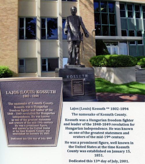
Kossuth County was founded on January 15, 1851. It was named after Lajos Kossuth, Regent-President of Hungary who went to exile to America following the war of independence of Hungary from Austria. The county was enlarged northward in 1857 by the inclusion of the former Bancroft County.
Geography
According to the U.S. Census Bureau, the county has an area of 974 square miles (2,520 km2), of which 973 square miles (2,520 km2) is land and 1.6 square miles (4.1 km2) (0.2%) is water. It is Iowa's largest county by area.
Major highways
Adjacent counties
National protected area
2010 census
The 2010 census recorded a population of 15,543 in the county, with a population density of 15.9741/sq mi (6.16765/km2). There were 7,486 housing units, of which 6,697 were occupied.
2000 census
As of the census of 2000, there were 17,163 people, 6,974 households, and 4,791 families residing in the county. The population density was 18 people per square mile (7/km²). There were 7,605 housing units at an average density of 8 per square mile (3/km²). The racial makeup of the county was 98.76% White, 0.11% Black or African American, 0.15% Native American, 0.35% Asian, 0.01% Pacific Islander, 0.29% from other races, and 0.34% from two or more races. 0.81% of the population were Hispanic or Latino of any race.
There were 6,974 households out of which 30.90% had children under the age of 18 living with them, 60.40% were married couples living together, 5.80% had a female householder with no husband present, and 31.30% were non-families. 28.70% of all households were made up of individuals and 15.50% had someone living alone who was 65 years of age or older. The average household size was 2.42 and the average family size was 2.98.
In the county, the population was spread out with 25.80% under the age of 18, 6.10% from 18 to 24, 24.30% from 25 to 44, 23.60% from 45 to 64, and 20.10% who were 65 years of age or older. The median age was 41 years. For every 100 females there were 95.30 males. For every 100 females age 18 and over, there were 94.00 males.
The median income for a household in the county was $34,562, and the median income for a family was $41,159. Males had a median income of $30,191 versus $20,184 for females. The per capita income for the county was $16,598. About 7.50% of families and 10.20% of the population were below the poverty line, including 12.40% of those under age 18 and 8.60% of those age 65 or over.
Census-designated places
Population ranking
The population ranking of the following table is based on the 2010 census of Kossuth County.
† county seat