
Length 303 km | ||
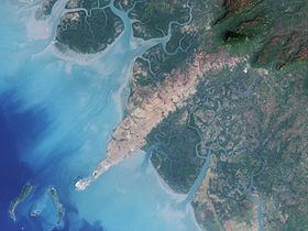 | ||
The Konkouré River arises in west-central Guinea and flows into the Atlantic Ocean. Several dams on the river provide the country with much of its electricity.
The river originates in the Futa Jallon highland region and flows in a westerly direction 303 kilometres (188 mi) to the Atlantic Ocean north of the Baie de Sangareya (Sangareya Bay) at 9°46'N, 14°19'W. The Kakrima River is its major tributary. The river delta covers 320 square kilometres (120 sq mi). The "Lower Konkouré is a shallow, funnel shaped, mesotidal, mangrove-fringed, tide dominated estuary". Rice farms have been established in the mangrove areas of the delta "with some success".
In 1999, the Garafiri Dam was opened at a cost of $221 million; it can produce 75 megawatts (101,000 hp) of electricity. Construction of a 240-megawatt (320,000 hp) hydroelectric dam on the river near Kaléta was completed in June 2015 and commissioned on 28 September at a cost of $526 million; the 1,545-metre (5,069 ft)-long dam lies about 120 kilometres (75 mi) or 85 miles (137 km) north of the capital city of Conakry. In 2015, the central government contracted with Chinese firms to begin building a 550-megawatt (740,000 hp) dam near Souapiti, about 2 kilometres (1.2 mi) further upstream, which would almost double Guinea's power generation output at an estimated cost of $2 billion. This would, however, require that 15,000 people move out of what would become a flood plain.
The river is home to 96 recorded freshwater fish species.
Vessels of up to 3 metres (9.8 ft) draft can navigate upstream to Konkouré; beyond that point, there are rapids.