
State Kingdom of Denmark Municipality seat Tórshavnar kommuna Highest elevation 478 m (1,568 ft) Area 2.8 km² Area code 298 | Area rank 17 Time zone GMT (UTC+0) Population 2 (2007) | |
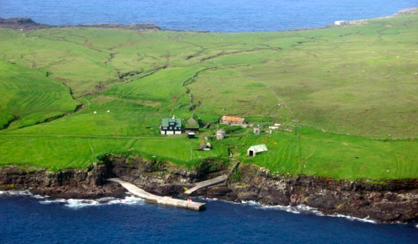 | ||
Koltur (Danish: Kolter) is an island in the Faroe Islands, located to the west of Streymoy and to the north of Hestur. The island has just one settlement, Koltur. It was abandoned in the 1980s by the sheep-farmers whose flocks grazed on the southern part of the island. Since then only two people have returned (in 1994). Koltur has two mountains, Kolturshamar (478 m) and Fjallið (101m) which strictly speaking is not a mountain, the name however translates directly as "The Mountain" and is considered by many as the smallest mountain in the country.
Contents
Map of Koltur, Faroe Islands
The island supports 160 adult sheep.
History
Archaeological excavations have found that barley has been cultivated on the island as far back as 800-900AD, in the early Viking age. And it has been cultivated up to near modern times, straw from Koltur was considered the best for thatching, as there are no mice in the island to diminish the quality of the straw.
There have been two settlements on the islands, Heima í Húsi and Norðuri í Gerði. There is a story that the two families who lived there couldn't agree to anything and never helped each other with anything, this went on for generations and in the end, it was forgotten what the original argument was about. Though the place-name Trætumørkin, hints at the argument being about a parcel of land.
All peat for fuel, had to be cut at Syðradal and Fossdal on Streymoy or later in Skopun, Sandoy, and then transported by boat back to Koltur where it was stored in houses at Gróthústanga.
Heima í Húsi is the older settlement, and it contains two farms, Niðri í Húsi and Uppi í Búð, and it is thought it is the original settlement on the island. The buildings are remarkably well preserved, although they have had running reparations through the centuries there has been very little modernization compared to the rest of the country, and thus give a great insight into how people have lived in the past.
Norðuri í Gerði is a younger settlement, but the old buildings here are in much worse condition, though in Jarðarbókini from 1584 it is established that this settlement already is built by then. This is the location of the only inhabited house today.
In 1890 there were 42 people living on the island spread over 6 families.
1954 was the last time anyone was buried in the cemetery. The cemetery lies some 600 meters to the north-east of the settlement Norðuri í Gerði, the isolation from the settlement is said to be due to it being haunted, as it could often go long stretches of time before a priest came to the island to throw earth on the grave, and put the dead properly to rest according to customs.
Important Bird Area
Most of the coastline of the island has been identified as an Important Bird Area by BirdLife International because of its significance as a breeding site for seabirds, especially European storm petrels (5000 pairs), Atlantic puffins (20,000 pairs) and black guillemots (50 pairs).