
Capital Kolozsvár 1910 5,006 km (1,933 sq mi) | Established 15th century 1910 286,700 | |
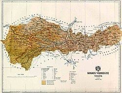 | ||
Kolozs was an administrative county (comitatus) of the Kingdom of Hungary, of the Eastern Hungarian Kingdom and of the Principality of Transylvania. Its territory is now in north-western Romania (north-western Transylvania). The capital of the county was Kolozsvár (present-day Cluj-Napoca).
Contents
Geography
After 1876, Kolozs county shared borders with the Hungarian counties Bihar, Szilágy, Szolnok-Doboka, Beszterce-Naszód, Maros-Torda and Torda-Aranyos. The rivers Sebes-Körös and Kis-Szamos flow through the county. Its area was 5006 km² around 1910.
History
Kolozs county was formed in the 11th century. In 1920, by the Treaty of Trianon the county became part of Romania. It was retaken by Hungary between 1940–1944 during World War II following the Second Vienna Award. Most of the territory of the county lies in the present Romanian county Cluj, some parts of the county are in the present Romanian counties Sălaj (north-west), Bistriţa-Năsăud (north-east) and Mureş (south-east).
Demographics
In 1900, the county had a population of 212,352 people and was composed of the following linguistic communities:
Total:
According to the census of 1900, the county was composed of the following religious communities:
Total:
In 1910, county had a population of 286,687 people and was composed of the following linguistic communities:
Total:
According to the census of 1910, the county was composed of the following religious communities:
Total:
Subdivisions
In the early 20th century, the subdivisions of Kolozs county were: