
Time zone GMT +5 (UTC+5) Population 58,267 (2009) | Area 5,868 km² Local time Thursday 9:33 PM | |
 | ||
Weather -1°C, Wind NW at 6 km/h, 81% Humidity | ||
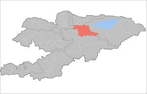
Kochkor is a raion (district) of Naryn Region in northern-central Kyrgyzstan. The capital lies at Kochkor. Its area is 5,868 square kilometres (2,266 sq mi), and its resident population was 58,267 in 2009.
Contents
Map of Kochkor District, Kyrgyzstan
Populated places
In total, Kochkor District includes 11 rural communities (aiyl okmotus). Each rural community comprises one or several villages. The rural communities and settlements in Kochkor District are as follows:
- Ak-Kyya aiyl okmotu (center - village Kara-Suu, and also village Jany-Jol)
- Kara-Suu aiyl okmotu (center - village Mantysh, and also villages Ak-Talaa, Kara-Moynok, Kyzyl-Töbö, Ortok)
- Kochkor aiyl okmotu (center - village Kochkor, and also villages Tendik, Bolshevik)
- Kosh-Debe aiyl okmotu (center - village Kara-Saz, and also village Kara-Küngöy)
- Kum-Döbö aiyl okmotu (center - village Kum-Döbö, and also villages Ak-Jar, Buguchu, Shamshy)
- Sary-Bulak aiyl okmotu (center - village Ak-Kyya, and also village Sary-Bulak)
- Semiz-Bel aiyl okmotu (center - village Kara-Too, and also villages Arsy, Semiz-Bel, Chekilbek )
- Talaa-Bulak aiyl okmotu (center - village Döng-Alysh, Komsomol)
- Kok-Jar aiyl okmotu (center - village Kok-Jar)
- Cholpon aiyl okmotu (center - village Cholpon, and also villages Ara-Köl, Tyuz, Epkin, Osoaviakhim)
- Song-Kul aiyl okmotu (center - village Tölök)
Also Keng-Suu, 6.9km from Sary-Bulak.
References
Kochkor District Wikipedia(Text) CC BY-SA