
Highest elevation 180 m (590 ft) Area 5.6 km² Area code 038 | District Bang Lamung Time zone ICT (UTC+7) Max length 4.3 km | |
 | ||
Village ListBan Ko LanBan Krok Makham Similar | ||
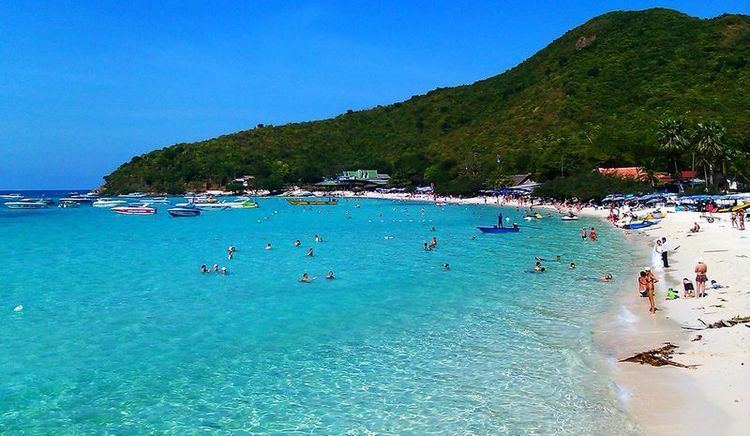
Ko Lan (Thai: เกาะล้าน, [kɔ̀ʔ láːn]) is one of the eastern seaboard islands of Thailand. Ko Lan lies 7.5 km from the nearest shore, Pattaya. "Ko Lan" is the name of the island in the Royal Thai General System of Transcription. It is also known as "Koh Larn" and "Ko Laan".
Contents
Map of Ko Lan, Chon Buri, Thailand
Geography
Ko Lan is the largest of the "near islands", off south Pattaya. It is at the southeast end of the Bay of Bangkok, on the east side of the Gulf of Siam. Administratively Ko Lan belongs to the Amphoe Bang Lamung, Chonburi Province.
It is about four kilometres in length and two kilometres in width. It is a hilly island, covered with low tropical forest; its highest point reaches 180 m where there is a Buddhist shrine. The island has two small villages: Ban Ko Lan and Ban Krok Makhan where there are lodgings and restaurants. There are ferries connecting Ko Lan to the mainland.
Most of Ko Lan's beaches are on its west side. Most visited is Tawaen Beach, where there is a small harbor. The length of the beach is lined with small tourist shops and restaurants. Other beaches are Tonglang Beach, Tien Beach, Samae Beach, and Naon Beach.
Ko Lan is inhabited by about 3,000 residents in 1,000 households, mostly clustered around the ferry pier.
The "Koh Larn Classic" is a sailing and running race event held at the nearby Royal Varuna Yacht Club in Pattaya.
Adjacent islands
Two smaller islands are near Ko Lan:
Ko Phai, the main island of Mu Ko Phai (หมู่เกาะไผ่), the group of "far islands", off Pattaya is about 14 km to the west of Ko Lan.
Impact of mass tourism
Ko Lan receives about 5,000 tourists per day, mostly Chinese, Russian, Indian, and Thai day-trippers from Pattaya. They generate about two million baht in daily income. They and the island residents also generate about 30 tonnes of solid waste per day, but Pattaya City authorities are only able to remove 20 tonnes per day. Pattaya City has no landfill of its own. It transports all of its waste and that of Ko Lan to a site in neighbouring Saraburi. The remaining daily 10 tonnes of refuse on Ko Lan is building up at a 12 rai sized dump site in the island's centre. Plans exist to build a garbage recycling and separation plant by 2016.