
Founded 1 April 1860 | Area 2,958 km² Population 39,550 (2013) | |
 | ||
Website www.knoxcountymaine.gov Rivers Great Brook, Dead River, Davis Stream, Medomak River Destinations Points of interest Farnsworth Art Museum, Penobscot Bay, Stephen Taber, Owls Head Light, Curtis Island | ||
Knox County is a county located in the state of Maine, in the United States. As of the 2010 census, the population was 39,736. Its county seat is Rockland. The county is named for American Revolutionary War general and Secretary of War Henry Knox, who lived in the county from 1795 until his death in 1806. The county was established on April 1, 1860, and is the most recent county to be created in Maine. It was carved from parts of Waldo and Lincoln counties. The Union Fair, started in 1868, began as the efforts of the North Knox Agricultural and Horticultural Society.
Contents
- Map of Knox County ME USA
- Geography
- Adjacent counties
- National protected areas
- 2000 census
- 2010 census
- Politics
- City
- Plantation
- Unorganized territories
- Census designated places
- Other unincorporated villages
- Public buildings
- References
Map of Knox County, ME, USA
Geography
According to the U.S. Census Bureau, the county has a total area of 1,144 square miles (2,960 km2), of which 365 square miles (950 km2) is land and 779 square miles (2,020 km2) (68%) is water. It is the second-smallest county in Maine by land area. It was originally part of the Waldo Patent.
Adjacent counties
National protected areas
2000 census
As of the census of 2000, there were 39,618 people, 16,608 households, and 10,728 families residing in the county. The population density was 108 people per square mile (42/km²). There were 21,612 housing units at an average density of 59 per square mile (23/km²). The racial makeup of the county was 98.28% White, 0.24% Black or African American, 0.22% Native American, 0.36% Asian, 0.01% Pacific Islander, 0.12% from other races, and 0.78% from two or more races. 0.57% of the population were Hispanic or Latino of any race. 25.4% were of English, 12.2% Irish, 11.7% United States or American, 7.5% German and 5.7% French ancestry according to Census 2000. 97.1% spoke English and 1.5% French as their first language.
There were 16,608 households out of which 28.30% had children under the age of 18 living with them, 52.20% were married couples living together, 9.00% had a female householder with no husband present, and 35.40% were non-families. 29.00% of all households were made up of individuals and 12.70% had someone living alone who was 65 years of age or older. The average household size was 2.31 and the average family size was 2.83.
In the county, the population was spread out with 22.40% under the age of 18, 6.30% from 18 to 24, 27.40% from 25 to 44, 26.70% from 45 to 64, and 17.20% who were 65 years of age or older. The median age was 41 years. For every 100 females there were 95.20 males. For every 100 females age 18 and over, there were 93.00 males.
The median income for a household in the county was $36,774, and the median income for a family was $43,819. Males had a median income of $30,704 versus $22,382 for females. The per capita income for the county was $19,981. About 6.40% of families and 10.10% of the population were below the poverty line, including 11.90% of those under age 18 and 8.00% of those age 65 or over.
2010 census
As of the 2010 United States Census, there were 39,736 people, 17,258 households, and 10,662 families residing in the county. The population density was 108.8 inhabitants per square mile (42.0/km2). There were 23,744 housing units at an average density of 65.0 per square mile (25.1/km2). The racial makeup of the county was 97.1% white, 0.5% black or African American, 0.5% Asian, 0.4% American Indian, 0.2% from other races, and 1.4% from two or more races. Those of Hispanic or Latino origin made up 0.8% of the population. In terms of ancestry, 31.3% were English, 19.0% were Irish, 12.8% were German, 6.9% were Scottish, and 5.9% were American.
Of the 17,258 households, 25.4% had children under the age of 18 living with them, 48.2% were married couples living together, 9.4% had a female householder with no husband present, 38.2% were non-families, and 31.0% of all households were made up of individuals. The average household size was 2.22 and the average family size was 2.75. The median age was 46.2 years.
The median income for a household in the county was $45,264 and the median income for a family was $55,830. Males had a median income of $40,712 versus $29,732 for females. The per capita income for the county was $25,291. About 7.9% of families and 12.5% of the population were below the poverty line, including 16.5% of those under age 18 and 9.8% of those age 65 or over.
Politics
In 2012, Knox County voted 55% in favor of a measure to legalize same-sex marriage.
City
Plantation
Unorganized territories
Census-designated places
Other unincorporated villages
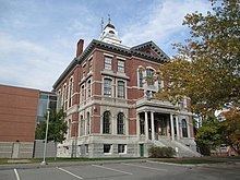
Public buildings
An addition to the Knox County Courthouse designed by Scott Simons Architects was completed 2005. It is connected to an annex built in 1977 that is adjacent to the historic, original building that was finished in 1874.