
Traversed by Federal Highway B78 Elevation 1,642 m | ||
 | ||
Similar Weinebene, Koralpe, Flattnitz Pass, Turracher Höhe Pass, Katschberg Pass | ||
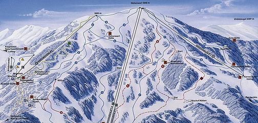
Klippitztörl (el. 1642 m.) is a mountain pass in the Austrian Alps in the Bundesland of Kärnten (or Carinthia).
Map of Klippitzt%C3%B6rl Pass, 9462 Wolfsberg, Austria
It connects Wolfsberg with St. Veit. The pass road is 28 km and goes south at Bad St. Leonhard from Federal Highway B78 over the pass to Lölling-Graben, where it joins Federal Highway B92 south of Hüttenberg.
There is a ski resort at the Hohenwart, with a number of lifts. Along the road, there are many hotels and rental chalets.
References
Klippitztörl Pass Wikipedia(Text) CC BY-SA