
Length 2.8 km (1.74 mi) Highest elevation 315 m (1,033 ft) County Sogn og Fjordane Area 250 ha | Width 1.8 km (1.12 mi) Highest point Kinnavarden Elevation 315 m Municipality Flora | |
 | ||
Location Sogn og Fjordane, Norway | ||
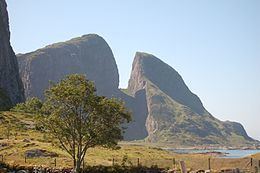
Kinn is an island in Flora Municipality which is in Sogn og Fjordane county, Norway. The island lies about 12 kilometres (7.5 mi) west of the town of Florø. The neighboring island of Reksta (where the village of Rognaldsvåg is located) lies just 350 metres (1,150 ft) to the east of Kinn, the island of Skorpa lies about 2.5 kilometres (1.6 mi) northeast of Kinn, and the island of Askrova lies about 9 kilometres (5.6 mi) to the southeast. The 2.5-square-kilometre (0.97 sq mi) island is dominated by a large mountain, with all its residents living on the east side. The mountain, Kinnaklova, is a very notable landmark to sailors in the region since it has a deep ravine that cuts through the center of the peak.
Contents
Map of Kinn, 6912 Kinn, Norway
The island is the home to the historic Kinn Church, dating back to the 12th century. The church was the seat of the large parish of Kinn for centuries. The island was also the centre (and namesake) of the old municipality of Kinn which existed from 1838 until 1964. The island can be reached by ferry from the town of Florø. The Kinnaspelet, a historical play, is performed on the island every summer.
The Ytterøyane Lighthouse is located about 3 kilometres (1.9 mi) northwest of the island.
Name
The island was named after the old Kinn farm (Old Norse: Kinn) since Kinn Church is located there. The name is identical with the word for "cheek", referring to the steep slope of a mountain on the island. Historically, the name was spelled Kind.