
Topo map USGS King's Peak Prominence 1,935 m Easiest route Hiking | Elevation 4,123 m | |
 | ||
Listing North America highest peaks 93rdNorth America isolated peaks 72ndUS highest major peaks 76thUS most prominent peaks 49thUS most isolated peaks 24thU.S. state high point 7thUtah county high points 1st Similar Gannett Peak, Gilbert Peak, Borah Peak, Mount Peale, Mount Elbert | ||
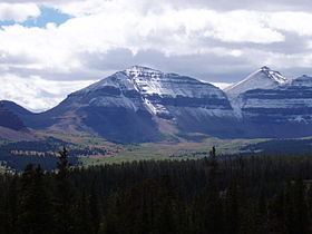
Kings Peak is the highest peak in the U.S. state of Utah, with an elevation of 13,534 feet (4,125 m) . It lies just south of the spine of the central Uinta Mountains, in the Ashley National Forest in northeastern Utah, in north-central Duchesne County. It lies within the boundaries of the High Uintas Wilderness. The peak is approximately 79 miles (127 km) due east of central Salt Lake City, and 45 miles (72 km) due north of the town of Duchesne.
Map of Kings Peak, Utah, USA
There are three popular routes to the summit; a scramble up the east slope, a hike up the northern ridge, and a long but relatively easy hike up the southern slope. The peak was named for Clarence King, a surveyor in the area and the first director of the United States Geological Survey. Kings Peak is generally regarded as the hardest state highpoint which can be climbed without specialist rock climbing skills and/or guiding. The easiest route requires a 29 mile round trip hike.