
District Ōshima Phone number 0997-65-1111 Local time Tuesday 2:15 AM Number of airports 1 | - Flower Agave Area 56.94 km² Population 7,657 (1 Jun 2013) | |
 | ||
Weather 18°C, Wind NW at 26 km/h, 87% Humidity | ||
Not to be confused with Kikai Caldera, which is submerged in the Ōsumi Islands
Contents
Map of Kikai, Oshima District, Kagoshima Prefecture, Japan
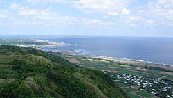
Kikai (喜界町, Kikai-chō) is a town located on Kikaijima, in Ōshima District, Kagoshima Prefecture, Japan.
In June 2013 the town had an estimated population of 7,657 and a population density of 134 persons per km². The total area is 56.94 km². The economy of the town is based on sugar cane, shochu refining, and seasonal tourism.
Geography
Kikai occupies all of the island of Kikaijima. The climate is classified as humid subtropical (Köppen climate classification Cfa) with very warm summers and mild winters. Precipitation is high throughout the year, but is highest in the months of May, June and September. The town is subject to frequent typhoons.
History
Kikai Village was established on April 1, 1908. It was upgraded to town status in 1941. As with all of the Amami Islands, the village came under the administration of the United States from 1 July 1946 to 25 December 1953.