
 | ||
The Kiev (Kyiv) metropolitan area (Ukrainian: Київська агломерація; Kyyivs’ka ahlomeratsia) is an unofficially-designated urban agglomeration in Ukraine within the Kiev Oblast, consisting of the country's capital city of Kiev, its satellite settlements and nearest rural areas closely bound to the city by employment and commerce. According to different sources, it is ranked among 20 largest metropolitan areas in Europe.
Contents
- Map of Kiev Metropolitan Area Ukraine
- Area and population
- Consisting urban settlements and administrative subdivisions
- Transport
- Environment
- References
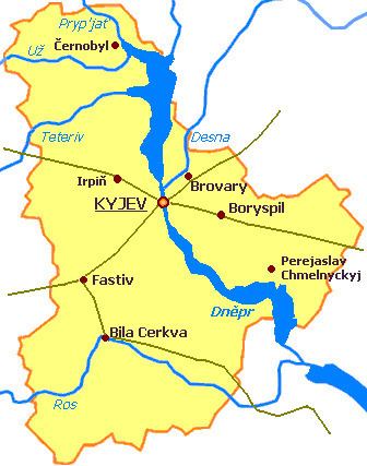
Map of Kiev Metropolitan Area, Ukraine
Area and population
Consisting urban settlements and administrative subdivisions
The metropolitan area includes the following cities: Kiev, Berezan, Boryspil, Brovary, Vasylkiv, Irpin, Rzhyschiv, and Fastiv. The city of Kiev also creates a very close conurbation with such cities as Irpin-Bucha, Brovary, Vyshhorod, and Vyshneve, while cities Boyarka and Boryspil are located in close vicinity. The town of Kotsiubynske is located within the city limits of Kiev, while being subordinate to the city council of Irpin.
The agglomeration stretches over some 11 raions of Kiev Oblast: Baryshivka,‹See TfD› Boryspil, Borodianka, Brovary, Fastiv, Kaharlyk,‹See TfD› Kiev-Sviatoshyn, Makariv, Obukhiv, Vasylkiv and Vyshhorod.
Transport
The area has a highly developed railway and road infrastructure, being linked to Kiev through the suburban railways, buses and minibuses.
Kiev metropolitan area is served by two international passenger airports: Boryspil Airport and Kyiv (Zhuliany) Airport; there are also the Gostomel cargo airport and additional three operating airfields facilitating airplane manufacturing and general aviation.
Environment
According to the UN 2011 evaluation, there were no risks of natural disasters in the Kiev metropolitan area