
Other name(s) Kickemuit River Country United States of America | Etymology Narragansett | |
 | ||
Cities Warren, Rhode Island
Rehoboth, Massachusetts | ||
The Kickamuit River is a river in the U.S. states of Massachusetts and Rhode Island flowing approximately 7.9 miles (12.7 km).
Contents
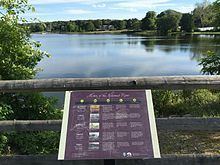
Map of Kickamuit River, Warren, RI, USA
History
The river's name descends from a Narragansett dialect and has numerous spellings.
During the American Revolutionary War, the Kickamuit was a major traffic artery, and supplies traveled up the river daily. By the 1800s, oyster beds were a major revenue source, but by 1910, the Parker Mills and sewage pollution killed most of the oysters. The Kickamuit River oyster industry was finished off by the Hurricane of 1938.
In, 2002 the Environmental Protection Agency judged it too polluted for recreation and shell-fishing.
Current day 2011, the Kickamuit River is classified as a Class A, Type II Waterway and open to both recreational activities and shell-fishing due to the tremendous efforts and work by environmental organizations like the Kickemuit River Council, Warren, R.I.
Course
The river's source is in Rehoboth, Massachusetts in the swamps north of Locust Street in Swansea. From here it flows due south to Swansea and into the Warren Reservoir, which drains approximately 2,300 acres (9.3 km2). From Warren Reservoir it flows generally southwest, then southeast to Mount Hope Bay, passing to the east of the center of the town of Warren, Rhode Island and ending northeast of Bristol. The Kickamuit Reservoir dam forms the boundary between fresh and salt water.
Crossings
Below is a list of crossings over the Kickamuit River. The list starts at the headwaters and goes downstream.
Tributaries
Heath Brook is the Kickamuit River's only named tributary, though it has many unnamed streams that also feed it.