
Country Thailand Time zone THA (UTC+7) Geocode 7602 Population 37,697 (2008) | Seat Khao Yoi Postal code 76140 Area 305.6 km² Province Phetchaburi Province | |
 | ||
Khao Yoi (Thai: เขาย้อย, [kʰǎw jɔ́ːj]) is a district (Amphoe) in the northern part of Phetchaburi Province, western Thailand.
Contents
Map of Khao Yoi District, Phetchaburi, Thailand
History
The district was established in 1897 and Luang Phromsan (หลวงพรหมสาร) was assigned as the first district officer. At first named Huai Luang, the district was renamed to Khao Yoi in 1903 due to the location of the district office.
Geography
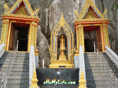
Neighboring districts are (from the north clockwise) Pak Tho of Ratchaburi Province, Amphawa of Samut Songkhram Province, Ban Laem, Mueang Phetchaburi, Ban Lat and Nong Ya Plong of Phetchaburi Province. The name of the district comes from the limestone hill called Khao Yoi which is just off the Phetkasem highway. The hill contains three caves, one of which has been converted to a cave temple with a notable reclining Buddha.
Administration
The district is subdivided into 10 subdistricts (tambon), which are further subdivided into 59 villages (muban). The subdistrict municipality (thesaban tambon) Khao Yoi covers parts of the tambon Khao Yoi, Sa Phang, Bang Khem and Thap Khang. There are further 7 Tambon administrative organizations (TAO) responsible for the non-municipal area.