
Location Phatthalung, Thailand Easiest route drive Mountain range Tenasserim Hills | Mountain type karstic Elevation 177 m Parent range Tenasserim Hills | |
 | ||
Similar Than Nam Yen, Thale Noi Waterfowl Reserve, Khao Nom Nang - Tha Kradan, Wat Khien Bang Kaeo, Khao Chaison Hot Spring | ||
Sidewalk and khao ok talu mountain
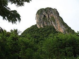
Khao Ok Talu or Phu Khao Ok Thalu (เขาอกทะลุ), is a mountain in Phatthalung Province, Thailand. It is a karstic formation.
Contents
- Sidewalk and khao ok talu mountain
- Map of Khao Ok Talu Khuha Sawan Muang Phatthalung District Phatthalung 93000 Thailand
- Tourism
- References
Map of Khao Ok Talu, Khuha Sawan, Muang Phatthalung District, Phatthalung 93000, Thailand
Tourism
This mountain is east of the Phatthalung railway station. It can be accessed from Wat Khuha Sawan via Highway 4047. There is a flight of stairs leading to the mountaintop where there is a Buddhist shrine overlooking the city of Phatthalung. The mountain is named after a hole near the top.
Khao Ok Talu is an unusually-shaped mountain, clearly visible from afar. It has symbolic significance in Phatthalung and appears in somewhat stylized form on the provincial seal of Phattalung.
References
Khao Ok Talu Wikipedia(Text) CC BY-SA