
Country Thailand Time zone ICT (UTC+7) Geocode 2210 Population 25,940 (2005) | Seat Phluang Postal code 22210 Area 830.2 km² Province Chanthaburi Province | |
 | ||
Khao Khitchakut (Thai: เขาคิชฌกูฏ, [kʰǎw kʰít.t͡ɕʰā.kùːt]) is a district (amphoe) in the central part of Chanthaburi Province, eastern Thailand.
Contents
Map of Khao Khitchakut District, Chanthaburi 22210, Thailand
History
The area was separated from Makham district and created to be a minor district (king amphoe) on 1 July 1993. .
Following a decision of the Thai government on 15 May 2007, all of the 81 minor districts were to be upgraded to full districts. With publication in the Royal Gazette on 24 August, the upgrade became official.
Geography
Neighboring districts are (from the west clockwise) Kaeng Hang Maeo, Soi Dao, Pong Nam Ron, Makham, Mueang Chanthaburi, and Tha Mai of Chanthaburi Province.
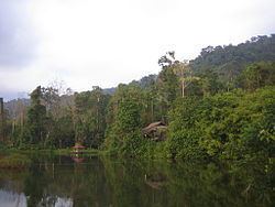
The important water resource is the Chanthaburi River, which originates within the area of the Khao Khitchakut National Park.
Administration
The district is subdivided into 5 communes (tambon), which are further subdivided into 46 villages (muban). There are no municipal (thesaban), and 5 tambon administrative organizations (TAO).