
Length 85 km | - elevation 1,000 m (3,281 ft) - elevation 0 m (0 ft) Basin area 1,080 km² Source Spitskop Province Western Cape | |
 | ||
Similar Tsitsikamma National Park, Birds of Eden, Robberg Nature Reserve, Monkeyland Primate Sanctuary, Outeniqua Mountains | ||
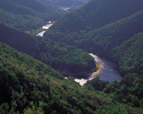
The Keurbooms River (Afrikaans: Keurboomsrivier) is a river in the Western Cape Province in South Africa. The river has its sources south of Uniondale in the Langkloof and flows in a roughly southeastern direction. It passes De Vlugt and the Prince Alfred Pass, flowing along the northern side of the R340 road then it turns south. After crossing the N2 road, it flows into the Indian Ocean through the Keurbooms Estuary, located close to the coastal town of Plettenberg Bay.
Contents
- Map of Keurboomsrivier South Africa
- 2 0 bedroom house for sale in keurbooms river plettenberg bay south africa for zar r 2 200 000
- Ecology
- References
Map of Keurboomsrivier, South Africa
The Keurbooms River is approximately 85 km long with a catchment area of 1,080 km2. Its main tributary is the Bitou (Bietou).
2 0 bedroom house for sale in keurbooms river plettenberg bay south africa for zar r 2 200 000
Ecology
The Keurbooms River marks the eastern limit of the area inhabited by the Cape galaxias (Galaxias zebratus), a South African fish species endemic to the Cape Floristic Region. It shares the same habitat as imported trouts and lives in an area between the Keurbooms and the Olifants River. Although in South Africa this relatively delicate fish is only classified as near threatened, in Australia species of the same genus were driven to extinction by competing salmonids.