
Largest settlement Basil Bay (pop. 80) | Total islands 70 Capital city Basil Bay Area 5.3 km² | |
 | ||
Local government area Whitsunday Regional Council | ||
Keswick Island is a picturesque island in the southern half of the Whitsunday Islands. Located 34 kilometres north-east of the Queensland city of Mackay, Keswick Island is part of the Cumberland Islands of islands that lay protected inside the waters of the Great Barrier Reef Marine Park.
Contents
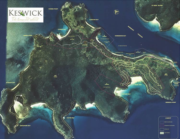
- Map of Keswick Island Queensland 4805 Australia
- Origin of the name
- Environs
- Development
- Activities
- Transport
- Accommodation
- Sale
- References
Map of Keswick Island, Queensland 4805, Australia
The island is inhabited by a small number of residents. It is a semi-popular tourist destination set to expand with planned development. Visitors can stay in a small number of catered and self-catered accommodation. The island has its own airstrip and is accessible from Mackay Airport by a short plane flight or by private boat.
Origin of the name
Identified as part of the Cumberland Isles Group by Captain James Cook in 1770. Keswick Island and neighbouring St Bees Island were first designated together as ‘L1 Island’ by Lieutenant Matthew Flinders, RN, in HMS Investigator in 1802.
Keswick Island was later individually named in 1879 after the town of Keswick in England's Cumbria Lake District by Staff Commander E. P. Bedwell, RN, in SS Llewellyn.
Environs
Keswick Island is approximately 530 hectares (1300 acres) in area, with the majority being national park. It is part of the pristine Cumberland Group of islands that consists of St Bees Island, Keswick Island, Aspatria Island, Scawfell Island, Calder Island, Wigton Island and Cockermouth Island. The island is near to the South Cumberland Islands National Park. Neighbouring islands in the Cumberland Group are accessible by private boat. The nearest developed neighbouring island is Brampton Island some 7 km to the north.
Keswick Island is separated from its nearest neighbour, St Bees Island by only a few hundred meters by the Egremont Passage. The eucalypt woodlands of St Bees Island are occupied by a healthy koala colony currently being researched by Queensland universities to examine their equilibrium with their environment.
The island is located 360 km north of the Tropic of Capricorn. Temperatures vary from 17 °C to 24 °C in winter (water temperature is a steady 20 °C), and 24 °C to 30 °C in summer (water temperature is a steady 26 °C).
Development
The overall land development lease area, which is situated in the north-eastern and eastern area of the Island, totals around 117 hectares and occupies over 4½ km of ocean front land. Resort complexes and residential housing capable of supporting a tourist and residential community are expected to be developed at some stage. The island already has some existing infrastructure such as an airstrip, sealed roads, communications services, and various utilities. The development company changed hands in 2002, and again in March 2008 to Keswick Developments Pty Ltd.
Located in a World Heritage Site and being within the waters of the Great Barrier Reef Marine Park requires that building and construction is governed by environmental guidelines, detailed architectural and design codes to facilitate an eco-friendly development.
Development in the Whitsunday Islands is limited. Keswick Islands still remains relatively undeveloped. The island is inhabited by a small number of private residents and visitors. With more than 100 sub-leased land lots already established on ninety-nine year leasehold (through to the year 2096), the numbers of residents and tourism should be expected to grow significantly with any planned development.
Activities
Visitors can enjoy the islands natural beauty with activities such as swimming, snorkeling, diving, fishing, beachcombing and bushwalking. Narrow walking tracks in the National Park wind through pockets of tropical rainforest to its beaches.
The island is fringed by colourful coral reefs and abundant marine life which provides favourable conditions for diving or snorkeling at mid-low tide. Three wrecks sites, including the protected historic wreck sites of The Singapore (a two master sail and steam vessel) and The Llewellyn (a former coastal steamer) are accessible from the island within a few minutes by boat.
Whales can be frequently seen around the island during their annual migration through the Whitsundays between July and September.
Transport
The closest transport hub is the city of Mackay. The island has its own sealed airstrip and is accessible from the old side of Mackay Airport on a short 10-minute flight with Keswick Development Pty Ltd's charter airline. It is also accessible from Mackay Harbour via chartered or private boat. Moorings are available.
Transport around the island is restricted to electric and petrol golf buggies.
Accommodation
Self-catered holiday homes are available for short-term rental.
Sale
While most of the island is designated as National Park, the islands head-lease (117 hectares) was sold to a Sydney property consortium in January 2008. Planned developments are said to include villas, condominiums, cafes and shops. Work on a deep-water jetty and improved barge ramps is expected to commence in the future to improve access to the island. The new owners plan to develop the islands residential and eco-tourism potential in a sustainable and environmentally friendly manner.