
Elevation 10 m (33 ft) Postal code 08610 Population 5,216 (2013) | District Hopa Time zone EET (UTC+2) Licence plate 08 Area code 466 | |
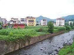 | ||
Kemalpaşa (former Makriyali; Laz and Georgian: მაკრიალი/Makriali or ნოღედი/Noghedi) is a coastal belde (town) in Hopa district of Artvin Province, Turkey. At 41°29′N 41°31′E it is 15 kilometres (9.3 mi) east of Hopa and 5 kilometres (3.1 mi) west of the Sarp border check point to Georgia. The population of the town was 5216 as of 2013.
Map of Kemalpa%C5%9Fa Belediyesi%2FHopa%2FArtvin, Turkey
Until 1547 it was a part of the Principality of Guria of the Kingdom of Imereti. In June 1367 here in Makriali Church the royal wedding took place between the king Bagrat V of Georgia and Anna of Trebizond. In 1547 it was annexed to Ottoman Empire. From 1915 to 1917 — occupied by the Russian Empire during the First World War. From 1918 to 1921 Kemalpaşa became a part of the Democratic Republic of Georgia. After the occupation of the Georgian Democratic Republic by the Soviet Red Army, the village was ceded to Turkey in 1922. In 1987 it was declared township.