
Population 163 (2011 Census) Civil parish Kelshall Local time Saturday 10:46 PM Dialling code 01763 | OS grid reference 32925 36376 | |
 | ||
Weather 9°C, Wind SE at 11 km/h, 85% Humidity | ||
Tricia lee kelshall x kevon carter call me baby 2016 christmas music release
Kelshall is a small village in North East Hertfordshire, England. It is near the town of Royston. It has a village hall and the local church is St. Faith's. Kelshall is also the name of the civil parish. Kelshall also has a major road running along one of its boundaries. In the 1880s the church was described as being "ancient, plain, and good, with a tower; and contains a few brasses and monuments".
Contents
- Tricia lee kelshall x kevon carter call me baby 2016 christmas music release
- Map of Kelshall Royston UK
- the magic of christmas on 107 7 featuring tricia lee kelshall kevon carter
- Economy
- Industry
- Travel
- Population
- Religion
- StFaiths Church
- References
Map of Kelshall, Royston, UK
the magic of christmas on 107 7 featuring tricia lee kelshall kevon carter
Economy
According to the 2011 Census, there are 87 economically active people in Kelshall, aged between 16–74. Only 22.3% of the total population is made up of full-time employees. There are 24 retired people, which make up 19.8% of the population.
According to the 2011 Census, 44 of the economically active people are males. 43 of these are female. "The rate of unemployment in Kelshall is both lower than the average for Hertfordshire and lower than the national average, suggesting that finding a job in this area may be easier than other places"
Industry
The amount of people in Kelshall that are in manufacturing is 9, (10.8%), compared to 1 person working in Real Estate Activities (1.2%) and 5 people working in Financial and Insurance Activities (6.0). There are many different industry's in Kelshall, "The parish is mainly agricultural, the chief crops being wheat, oats and roots, and only a small proportion of the land is laid down to pasture".
Travel
There are many key destinations that are accessible from Kelshall, using their local bus service, these are Royston, Hitchin and Letchworth. "The village lies about 2 miles to the south of the Icknield way, with which it is connected by roads leading north, joining in the village and thence going to Therfield and the Ermine Street at Buckland". There is also a road that leads to Buckland and this is where the main part of the village is actually situated.
Population
The population of Kelshall, on average, is actually older than the average age of Hertfordshire, also "The population of Kelshall as a whole, is older than the national average"
As the graph shows, the population had increased from 1801 when it was 179 to the year 1851 when it was 326 and this was the peak population of Kelshall within this time period. From this year it then slowly decreased and the lowest the population stood at was 122 in 1961. According to the 2001 census, the population stood at 151. 79 of these people were married and that was their first marriage. 43 people were single and had never been married, while 9 people had been re-married. The 2011 census shows a population of 163.
Religion
As the graph shows, in 2001 there were 124 Christians in Kelshall. This group of people made up 73% of the population, at that time. This then decreased in 2011 as the number of Christians then was only 119, however, the percentage of Christians had actually gone up to 83.2% due to an overall population increase in Kelshall. From 2001–11 the number of Muslims increased from 0–2 and the amount of non-religious people also experienced some change. In 2001 this number stood at 17, this means that this group of people made up 11.4% of the population at the time. This then increased in 2011 to 28 people, which was then 17.2% of the population.
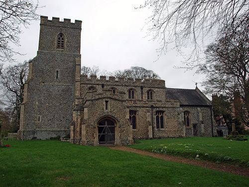
St.Faith's Church
St.Faith's Church was restored thoroughly from 1868–70. It is situated on the edge of the village and the ceilings are painted in a medieval style, which was done recently. The south door is also described as being "contemporary". "Several small ponds lie on the east of the church, and from the formation of the ground it appears probable that there was once a moat here".