
Time zone CET/CEST (UTC+1/+2) Area 40.54 km² Population 3,761 (31 Dec 2008) Dialling code 034651 | Elevation 157 m (515 ft) Postal codes 06537 Local time Saturday 9:46 PM Postal code 06537 | |
 | ||
Weather 3°C, Wind NE at 8 km/h, 87% Humidity | ||
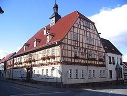
Kelbra is a town the Mansfeld-Südharz district, in Saxony-Anhalt, Germany. It is situated north of the Kyffhäuser mountains, approx. 20 km west of Sangerhausen, and 20 km east of Nordhausen. Kelbra is part of the Verbandsgemeinde Goldene Aue.
Contents
Map of Kelbra, Germany
Kelbra lies on the northern slopes of the Kyffhäuser mountains in der Goldene Aue. The B 85 federal road starts in the neighbouring village of Berga and runs through Kelbra over the Kyffhäuser to Passau.
Due to the proximity of the Kelbra Dam and the Kyffhäuser, the town is a type of tourist centre, but suffers from heavy day traffic, especially motorcycles, because the road climbing up to the Kyffhäuser starts here.
Nearby are the Barbarossa Cave and the Peasants' War Panorama in Bad Frankenhausen.
The villages of Sittendorf, Tilleda (Kyffhäuser) and Thürungen belong to the municipality of Kelbra.
Town twinning
Kelbra is twinned with the English village of Frampton Cotterell and the German town of Bad Salzdetfurth.