
 | ||
Colleges and Universities Esa Unggul University, Inti College Indonesia, Al Kamal Points of interest Gedung Arsip KESDM, Takei Ratax Wisata, Musholah An‑Nur | ||
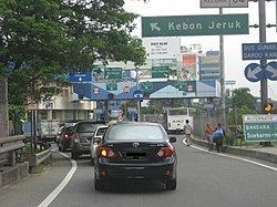
Kebon Jeruk (Indonesian for "orange garden") is a subdistrict (kecamatan) of West Jakarta, Indonesia. Kebon Jeruk is roughly bounded by Kali Pesanggrahan creek to the west, Kebayoran Lama Road to the south, Daan Mogot Road to the north, and Rawa Belong - Batu Sari Road to the east. The area is approximately 18 square km.
Contents
- Map of Kebon Jeruk West Jakarta City Jakarta Indonesia
- Kelurahan administrative villages
- List of important places
- Housing Estates
- References
Map of Kebon Jeruk, West Jakarta City, Jakarta, Indonesia
The Jakarta–Tangerang Toll Road passes through the subdistrict, connecting Jakarta to Merak in Banten Province. The major streets in Kebon Jeruk are Panjang Road, Arjuna Utara (North Arjuna) and Arjuna Selatan (South Arjuna) Roads, and Perjuangan Road.
Kelurahan (administrative villages)
The subdistrict of Kebon Jeruk is divided into seven kelurahan or administrative villages:
List of important places
Housing Estates
References
Kebon Jeruk Wikipedia(Text) CC BY-SA