
Local time Saturday 1:39 PM | ||
 | ||
Weather 9°C, Wind E at 29 km/h, 51% Humidity | ||
Kaymakli underground city turkey full hd
Kaymakli Underground City (Turkish: Kaymaklı; Cappadocian Greek: Ανακού) is contained within the citadel of Kaymakli in the Central Anatolia Region of Turkey. First opened to tourists in 1964, the village is about 19 km from Nevşehir, on the Nevşehir-Niğde road.
Contents
- Kaymakli underground city turkey full hd
- Map of KaymaklC4B1 50760 KaymaklC4B1 Belediyesi2FNevC59Fehir Merkez2FNevC59Fehir Turkey
- Turkey cappadocia kaymakli underground city
- History
- Description
- References
Map of Kaymakl%C4%B1, 50760 Kaymakl%C4%B1 Belediyesi%2FNev%C5%9Fehir Merkez%2FNev%C5%9Fehir, Turkey
Turkey cappadocia kaymakli underground city
History
The ancient name was Enegup. Caves may have first been built in the soft volcanic rock by the Phrygians, an Indo-European people, in the 8th–7th centuries B.C., according to the Turkish Department of Culture. When the Phrygian language died out in Roman times, replaced with Greek, to which it was related, the inhabitants, now Christians, expanded their underground caverns adding the chapels and inscriptions. The city was used in the Byzantine era for protection from Muslim Arabs during the Arab–Byzantine wars (780-1180). The city was connected with Derinkuyu underground city through miles of tunnels. Some artifacts discovered in these underground settlements belong to the Middle Byzantine Period, between the 5th and the 10th centuries A.D. These cities continued to be used by the Christian inhabitants as protection from the Mongolian incursions of Timur in the 14th century. After the region fell to the Ottomans, the cities were used as refuges (καταφύγια) from the Turkish Muslim rulers, and as late as the 20th century the inhabitants, called Cappadocian Greeks, were still using the underground cities to escape periodic waves of Ottoman persecution. Dawkins, a Cambridge linguist who conducted research on the Cappodocian Greeks in the area from 1909-1911, recorded that in 1909,
When the Christian inhabitants of the region were expelled in 1923 in the Population exchange between Greece and Turkey the tunnels were abandoned.
Description
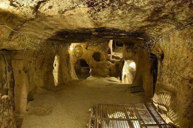
The houses in the village are constructed around the nearly one hundred tunnels of the underground city. The tunnels are still used today as storage areas, stables, and cellars. The underground city at Kaymakli differs from Derinkuyu in terms of its structure and layout. The tunnels are lower, narrower, and more steeply inclined. Of the four floors open to tourists, each space is organized around ventilation shafts. This makes the design of each room or open space dependent on the availability of ventilation.
A stable is located on the first floor. The small size of the stable could indicate that other stables exist in the sections not yet opened. To the left of the stable is a passage with a millstone door. The door leads into a church. To the right of the stables are rooms, possibly living spaces.
Located on the second floor is a church with a nave and two apses. Located in front of the apses is a baptismal font, and on the sides along the walls are seating platforms. Names of people contained in graves here coincide with those located next to the church, which supports the idea that these graves belonged to religious people. The church level also contains some living spaces.
The third floor contains the most important areas of the underground compound: storage places, wine or oil presses, and kitchens. The level also contains a remarkable block of andesite with relief textures. Recently it was shown that this stone was used for cold-forming copper. The stone was hewn from an andesite layer within the complex. In order for it to be used in metallurgy, fifty-seven holes were carved into the stone. The technique was to put copper into each of the holes (about 10 centimetres (3.9 in) in diameter) and then to hammer the ore into place. The copper was probably mined between Aksaray and Nevsehir. This mine was also used by Asilikhoyuk, the oldest settlement within the Cappadocia Region.
The high number of storage rooms and areas for earthenware jars on the fourth floor indicates some economic stability. Kaymakli is one of the largest underground settlements in the region. The large area reserved for storage in such a limited area appears to indicate the need to support a large population underground. Currently only a fraction of the complex is open to the public.