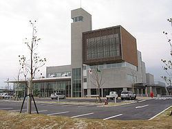
Population 14,435 (Nov 2012) | - Tree Round Leaf Holly Area 8.71 km² Local time Saturday 5:05 PM | |
 | ||
Weather 7°C, Wind NW at 29 km/h, 56% Humidity | ||
Kawagoe (川越町, Kawagoe-chō) is a town located in Mie Prefecture, Japan. As of November 2012, the town had an estimated population of 14,435 and a population density of 1660 persons per km². The total area was 8.71 km².
Contents
- Map of Kawagoe Mie District Mie Prefecture Japan
- Geography
- Neighboring municipalities
- History
- Railway
- Highway
- Noted people
- References
Map of Kawagoe, Mie District, Mie Prefecture, Japan
Geography
Kawagoe is located in northeastern Mie Prefecture, in the lowlands bordering on Ise Bay. Parts of the municipality are polders, at (or near) sealevel.
Neighboring municipalities
History
The area of present-day Kawagoe was part of the holdings of Kuwana Domain in the Edo period, and was an area of large scale land reclamation projects by the Domain to increase its rice lands. During the Meiji period, Kawagoe was one of the villages established within Asake District of Mie Prefecture in 1889. Asake District was abolished in 1896, and merged with Mie District. Kawagoe village was raised to town status on October 17, 1957.
