
Last eruption January 2014 First ascent 1939 | Elevation -20 m | |
 | ||
Volcanic arc/belt Bougainville & Solomon Is. Similar Tinakula, Metis Shoal, Lopevi, Nabukelevu, Fonualei | ||
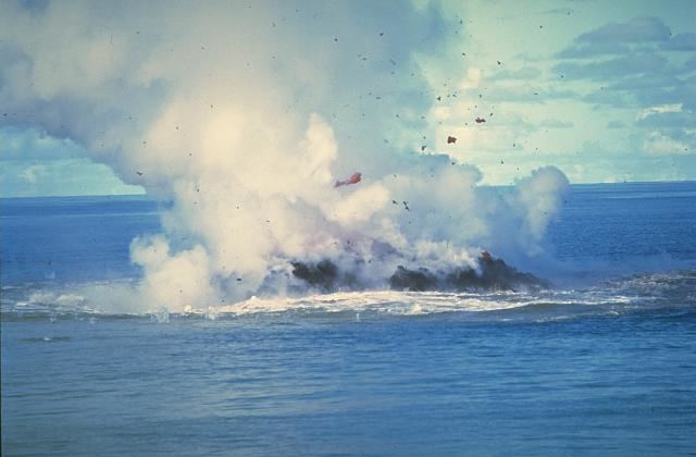
Kavachi is one of the most active submarine volcanoes in the south-west Pacific Ocean. Located south of Vangunu Island in the Solomon Islands, it is named after a sea god of the New Georgia Group islanders, and is also referred to locally as Rejo te Kavachi ("Kavachi's oven’). The volcano has become emergent and then been eroded back into the sea at least eight times since its first recorded eruption in 1939.
Map of Kavachi Submarine Volcano, Solomon Islands
In May 2000, an international research team aboard the CSIRO research vessel FRANKLIN fixed the position of the volcano at 8° 59.65'S, 157° 58.23'E. At that time the vent of the volcano was below sea level, but frequent eruptions ejected molten lava up to 70 metres (230 feet) above sea level, and sulfurous steam plumes up to 500 metres (1,600 feet). The team mapped a roughly conical feature rising from 1,100 metres (3,600 feet) water depth, with the volcano having a basal diameter of about 8 kilometres (5.0 miles).
When the volcano erupted in 2003, a 15-metre-high (49-foot) island formed above the surface, but it disappeared soon after. Additional eruptive activity was observed and reported in March 2004 and April 2007.
In 2015, marine wildlife has been found living inside the Kavachi crater, including two species of sharks and a sixgill stingray.