
Incorporated 1885 Zip code 54130 Local time Friday 11:59 PM | Settled 1793 Area 20.88 km² Population 15,725 (2013) | |
 | ||
Weather -11°C, Wind NW at 21 km/h, 34% Humidity | ||
Kaukauna /kəˈkɔːnə/ is a city in Outagamie and Calumet counties, Wisconsin, United States. It is situated on the Fox River, approximately 100 miles (160 km) north of Milwaukee. The population was 15,462 at the 2010 census. It is a part of the Appleton, Wisconsin Metropolitan Statistical Area.
Contents
- Map of Kaukauna WI 54130 USA
- History
- Geography
- 2010 census
- 2000 census
- Transportation
- Economy
- Education
- Religion
- National Register of Historic Places
- References
Map of Kaukauna, WI 54130, USA
History
Kaukauna is a Native American word and in various dialects means "portage", "long portage", "place where pickerel are caught", and "place of pike". Prior to 1880, and shortly afterwards, Kaukauna was known as "The Lion on the Fox". This nickname was changed to "The Electric City" upon the completion of the hydroelectric plant. When the city was incorporated in 1885, it was separated from the adjacent rural parts of the town. The first recorded land deed in Wisconsin was assigned to Dominique Ducharme in 1793. He obtained 1,281 acres (518 ha) from the Menominee Indians for two barrels of rum and other gifts. These acres are the original site of the town of Kaukauna. The property was purchased by Charles A. Grignon (and recorded Dec. 18, 1828), who built a mansion on the river on Kaukauna's north side. The home, which bears Grignon's name, is operated as a museum by the Outagamie County Historical Society.
Geography
Kaukauna is located in southeastern Outagamie County, with a small portion extending south into Calumet County along State Highway 55 (Friendship Drive). According to the United States Census Bureau, the city has a total area of 8.06 square miles (20.88 km2), of which 7.66 square miles (19.84 km2) is land and 0.40 square miles (1.04 km2) is water.
The city is divided into the North Side and South Side by the Fox River, which is spanned by four bridges.
2010 census
As of the census of 2010, there were 15,462 people, 6,270 households, and 4,090 families residing in the city. The population density was 2,018.5 inhabitants per square mile (779.3/km2). There were 6,596 housing units at an average density of 861.1 per square mile (332.5/km2). The racial makeup of the city was 94.5% White, 0.7% African American, 0.8% Native American, 1.3% Asian, 1.0% from other races, and 1.6% from two or more races. Hispanic or Latino of any race were 2.6% of the population.
There were 6,270 households of which 33.9% had children under the age of 18 living with them, 50.2% were married couples living together, 10.3% had a female householder with no husband present, 4.8% had a male householder with no wife present, and 34.8% were non-families. 27.9% of all households were made up of individuals and 10.6% had someone living alone who was 65 years of age or older. The average household size was 2.45 and the average family size was 3.01.
The median age in the city was 34.6 years. 25.8% of residents were under the age of 18; 8.3% were between the ages of 18 and 24; 29.5% were from 25 to 44; 24.2% were from 45 to 64; and 12.2% were 65 years of age or older. The gender makeup of the city was 49.5% male and 50.5% female.
2000 census
As of the census of 2000, there were 12,983 people, 4,971 households, and 3,365 families residing in the city. The population density was 2,092.5 people per square mile (808.5/km²). There were 5,142 housing units at an average density of 320.2 persons/km² (828.8 persons/sq mi). The racial makeup of the city was 95.48% White, 0.27% African American, 0.75% Native American, 2.22% Asian, 0.07% Pacific Islander, 0.30% from other races, and 0.91% from two or more races. 0.79% of the population were Hispanic or Latino of any race.
There were 4,971 households out of which 35.5% had children under the age of 18 living with them, 55.0% were married couples living together, 8.7% have a woman whose husband does not live with her, and 32.3% were non-families. 26.6% of all households were made up of individuals and 12.3% had someone living alone who was 65 years of age or older. The average household size was 2.57 and the average family size was 3.16.
In the city, the population was spread out with 27.7% under the age of 18, 8.6% from 18 to 24, 30.5% from 25 to 44, 19.4% from 45 to 64, and 13.7% who were 65 years of age or older. The median age was 35 years. For every 100 females there were 97.0 males. For every 100 females age 18 and over, there were 94.4 males.
The median income for a household in the city was $43,980, and the median income for a family was $50,187. Males had a median income of $38,880 versus $22,830 for females. The per capita income for the city was $18,748. 4.8% of the population and 2.6% of families were below the poverty line. Out of the total people living in poverty, 4.6% are under the age of 18 and 10.4% are 65 or older.
Transportation
Kaukauna is located at the intersections of several major roads. US 41, which forms the backbone of the Fox Cities' transit network, runs along the northern edge of the city and intersects Wisconsin Highway 55, Wisconsin Highway 96, and two county roads that serve as major thoroughfares in the city. US 10 is just to the south of Kaukauna, and Wisconsin Highway 441 is just to the west. Kaukauna is a member of Valley Transit, which provides bus service.
Economy
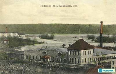
The city has diverse industrial and manufacturing businesses, including the Oscar Thilmany Paper Mill, constructed in 1883. The name dropped off the mill when it was purchased by HammerMill in 1969, which was in turn bought by International Paper in 1986.
In 2005, New York-based equity firm Kohlberg & Company bought the mill, changed the name back to Thilmany, and created a company of the same name. It is now owned by KPS Capital Partners, and was renamed Expera Specialty Solutions in 2013. Kaukauna cheese, once made in the city, is now manufactured by the Bel/Kaukauna corporation in the neighboring village of Little Chute.
Education
Kaukauna is served by the Kaukauna Area School District, whose enrollment totals almost 4,000 students between kindergarten and 12th grade. The city has four elementary schools and one middle school. Two parochial schools for children through the eighth grade exist in Kaukauna. Kaukauna's Catholic parishes have created the Kaukauna Catholic School System, and Trinity Lutheran School is operated by Trinity Lutheran Church.
Kaukauna has one public high school, named for the city, with an enrollment of approximately 1,350. The current school was constructed in 1999 to replace the first Kaukauna High School, which the district had outgrown despite expanding the building twice after its construction in the late 19th century. The school's mascot is the Galloping Ghost, named after a football game in the early days of the school. On a foggy night, the announcer was heard to describe the running back as a Galloping Ghost - possibly a reference to Red Grange, a professional football player whose nickname was "The Galloping Ghost". Kaukauna athletics participate in the Fox Valley Association Conference with nine other Fox Valley schools.
Religion
Kaukauna has two Lutheran churches: Bethany Lutheran Church (Missouri Synod) and Trinity Lutheran Church (Wisconsin Synod), and three Roman Catholic churches: Holy Cross, St. Mary's and St. Aloysius.
National Register of Historic Places
Locations in Kaukauna that are listed on the National Register of Historic Places: