
Coat of arms Flag Town Kashira Local time Saturday 12:21 AM | Area 26.35 km² | |
 | ||
Weather 1°C, Wind S at 16 km/h, 79% Humidity | ||
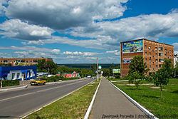
Kashira (Russian: Каши́ра) is a town and the administrative center of Kashirsky District in Moscow Oblast, Russia, located on the Oka River 115 kilometers (71 mi) south of Moscow. Population: 41,870 (2010 Census); 40,898 (2002 Census); 44,110 (1989 Census).
Contents
- Map of Kashira Moskovsky Russia
- Re zero beatrice kashira compilation i suppose
- History
- Administrative and municipal status
- Economy
- References
Map of Kashira, Moskovsky, Russia
Re zero beatrice kashira compilation i suppose
History
It was first mentioned in 1356 as the village of Koshira (Кошира) named after the Koshira River (today's Kashirka River). However, 1619 is considered Kashira's foundation year, when the town was transferred from the left bank of the Oka to the right bank some 5 kilometers (3.1 mi) upstream and rebuilt after it was badly damaged by the Crimean Tatars in 1592 and 1596.
The town was once home to exiled Kazan Khan Ghabdellatif. The coat of arms of Kashira contains the image of Zilant, a heraldic symbol of Kazan.
Town status was granted to Kashira in 1777.
Administrative and municipal status
Within the framework of administrative divisions, Kashira serves as the administrative center of Kashirsky District. As an administrative division, it is, together with five rural localities, incorporated within Kashirsky District as the Town of Kashira. As a municipal division, the Town of Kashira is incorporated within Kashirsky Municipal District as Kashira Urban Settlement.
Economy
A large thermal power plant operates in Kashira. In 1950, the terminal of the first HVDC-transmission was built in the town.