
Time zone EET (UTC+2) Area code(s) 22x0 Area 672.4 km² Local time Friday 9:52 PM | Lowest elevation 0 m (0 ft) Postal code 340 01 Vehicle registration XA Population 5,112 (2011) Administrative region Central Greece | |
 | ||
Weather 12°C, Wind N at 18 km/h, 80% Humidity | ||
Karystos
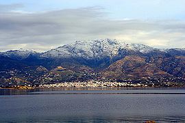
Karystos (Greek: Κάρυστος) or Carystus is a small coastal town on the Greek island of Euboea. It has about 5,000 inhabitants (12,000 in the municipality). It lies 129 km south of Chalkis. From Athens it is accessible by ferry via Marmari from the port of Rafina. Its urban plan was laid out by the renowned Bavarian civil engineer Bierbach, in the middle of the 19th century, near the site of the ancient city of Carystus.
Contents
- Karystos
- Map of Karistos 340 01 Greece
- Karystos kontres alhteia
- History
- Municipality
- Tourist sites
- Notable people
- References
Map of Karistos 340 01, Greece
Karystos kontres alhteia
History
Karystos apparently remained inhabited throughout the early Middle Ages. As part of the theme of Hellas, it was also seat of a bishop – a suffragan of Athens – at least since the reign of Leo VI the Wise (r. 886–912). It was among the towns listed in the 1198 chrysobull of Alexios III Angelos, where the Venetians were permitted to establish trade stations. In 1205 it was captured, as with the rest of the island, by Jacques d'Avesnes, and soon it became the seat of the southern third (triarchy) of Euboea under Ravano dalle Carceri.
It is likely that it was at this time, with the construction of the castle of Castel Rosso (some 4 km from the modern town, at the modern village of Myloi) and the rise of piracy, that the town was moved from its coastal location to the inland around Castel Rosso. The town remained an episcopal see under Latin rule, with the Greek bishop remaining in office; in 1222 however it was merged with the Bishopric of Euripos (Chalcis). In 1276/7 it was reconquered by the Byzantines under Licario and held until 1296, when it was recovered by Boniface of Verona. In 1318 it passed into Catalan hands as part of the dowry of Marulla of Verona for her marriage with Alfonso Fadrique. The town was coveted by the Venetians, who already in 1339 offered to purchase it; negotiations dragged on until 1365, however, and only in 1366 did Karystos finally pass into Venetian control when Boniface Fadrique sold the barony to the Republic. After the conquest of Euboea by the Ottoman Empire in 1470, the local Orthodox see was reactivated as part of the Metropolis of Euripos.
Municipality
The municipality Karystos was formed at the 2011 local government reform by the merger of the following 4 former municipalities, that became municipal units:
The municipality has an area of 674.635 km2, the municipal unit 166.950 km2.