
Country India Languages spoken Konkani, Kannada Area 27.9 km2 | State Karnataka District Uttara Kannada | |
 | ||
Colleges and Universities Divekar College of Commerce, Arts and Science College, Karwar | ||
Map of Karwar, Karnataka
Karwar (Kannada: ಕಾರವಾರ, Konkani: कारवार) is a city in Uttara Kannada district in the South Indian state of Karnataka and the administrative centre of Uttara Kannada district. Karwar lies on the west coast of Southern India at the mouth of the Kali river. Its geography creates a natural harbour with protection against monsoon weather. Being a port town, Karwar is a centre for agriculture, manufacturing and tourism.
Contents
- Map of Karwar Karnataka
- Karwar City Karnataka
- Etymology
- History
- Geography
- Biodiversity
- Climate
- Demographics
- Language
- Religion
- Primary industry
- Secondary industry
- Tertiary industry
- Karwar Airport
- Konkan railway
- INS Kadamba
- INS Vajrakosh
- Karwar port
- Aditya Birla Chemicals
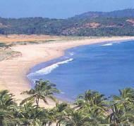
- Rabindranath Tagore beach
- Seaside
- Hinterland
- Historic sites
- Cuisine
- Local Festivals
- Media
- Notable residents
- Connectivity
- Villages of Karwar
- References
Karwar City Karnataka
Etymology
Karwar derived its name from the nearby village of Kadwad (Kade Wada, the last wado). Kade means last and wado means precinct or area in Konkani and Kannada. Before Indian independence, the name Karwar was spelt Carwar. The name Baithkhol, is an Arabic term. Bait-e-kol, means bay of safety.
History
Kot Siveshvar, another fortress, was built near Karwar (in Siveshvar village) by the Sultan of Bijapur to counterattacks from the north. At the ruins of Fort Siveshvar are a Muslim graveyard and a tunnel at the eastern gate.
Portuguese traders knew Karwar as Cintacora, Chitrakul, Chittakula or Sindpur. In 1510, the Portuguese captured and burnt a fort at Karwar. They called it Fort Pir, Forte de Piro or Pito due to the presence of a Muslim Dargah (tomb of a Sufi saint, Shahkaramuddin). In the 17th century, refugees from Portuguese rule in Goa moved to Karwar.
Marathas: Having marched from Bednore in the south, visiting on his way the sacred temple at Gokarna, Chhatrapati Shivaji Maharaj seized Ankola and the next day came to Karwar (then known as Kadwad).[1] Both the East India Company and Sher Shah, the sardar of Bijapur, were very much alarmed at this sudden development. They collected huge amount and offering it to Shivaji, prayed that they may be spared. Satisfied at the recognition of his authority, Shivaji crossed the Kali River and conquered Sadashivgad on 21st Feb 1665;
In 1638 the English trading Courteen Association established a factory at Kadwad village, 6 km east of Karwar and traded with merchants from Arabia and Africa. The common commodities were muslin, black pepper, cardamom, cassier and coarse blue cotton cloth. In 1649 the Courteen Association merged with the British East India Company, and Karwar became a company town.
The East India Company built fighting ships in the Karwar harbour. For example, the Britannia (1715) which had 18 guns was built to defend Bombay from attacks by Maratha admiral Kanhoji Angre.
In the 1700s Karwar was part of the Maratha Empire. In 1784, at the time of the Treaty of Mangalore between Tipu Sultan and the East India Company, Karwar and Sadashivgad were spelt Carwar and Sadasewgude, respectively. After the defeat of the Marathas in the Third Anglo-Maratha War, Karwar fell to the British.
The Bengali poet and Nobel laureate Rabindranath Tagore, who visited Karwar in 1882, dedicated a chapter of his memoirs to this town. At 22 years, Tagore stayed with his second brother, Satyendranath Tagore, who was a district judge in Karwar.
From 1862 to the re-organisation of the states, Uttara Kannada district was part of the Bombay Presidency. During this time, major public works carried out included improvement of roads, building of a wharf, wharf road and a sea wall at the Karwar port as well as the construction of a multi-floor storage building, staff housing, a post office, kutcheri (kutcherries or zamindar's offices) and a Christian burial ground.
During World War II Karwar was an Indian Naval training site.
Geography
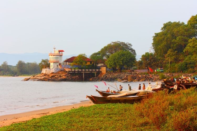
Karwar is a seaside city on the west coast of the Indian peninsula. To the east are the Western Ghats. Karwar is situated on the banks of the Kali river (Kali nadi) which flows west to the Arabian sea from its headwaters at Bidi village in the Western Ghats. The Kali river has a length of about 153 km and is the main source of irrigation for Karnataka. Karwar is 15 kilometres (9.3 mi) south of the Karnataka - Goa border, 273 kilometres (170 mi) north of Mangalore and 519 kilometres (322 mi) north-west of Bangalore, the capital city of Karnataka.
Baitkhol port at Karwar is a natural harbour with land side hills and ocean side islands protecting it from cyclonic weather. The four fathom mark lies close to the shore. The tidal range is 1.2 to 2.5m.
Biodiversity
Several small mangrove covered islands lie off the Kali river estuary including Anjadip Island and Devagadaguda Islands. The sub-tidal regions of the islands have a high biodiversity, although the waters off Karwar have recorded higher than normal faecal coliform counts.
Climate
Karwar lies on a coastal strip known as the Monsoon Coast. Karwar has hot summers from March to May where the temperature may reach 37 °C. The Arabian Sea is warm throughout the year. Winters from December to February are very mild (24 °C and 32 °C). The windy monsoon period from June to September has an average rainfall of over 400 centimetres (160 in).
Demographics
As of the 2011 Census of India, the total population in Karwar is 155,213.
Language
Kannada is the official state language. The regional language Konkani and Marathi are also widely spoken language from before the British Ruled In India And Also influenced by the neighbouring state of Goa.
Religion
Most people in Karwar are Hindu. Christianity was introduced to Karwar by the British and by the Portuguese in Goa in the 17th and 18th centuries. Muslim seafaring traders migrated to Karwar from the Deccan (Bahamani) kingdoms.
Primary industry
Karwar is an agricultural region. The common crops are rice, groundnuts, green vegetables, onions, watermelons and flowers. Other primary industries include animal husbandry, sericulture, horticulture, beekeeping, gathering and lumbering and the growing of homeopathic medicinal plants.
The coastal location of Karwar lends to fishing and fisheries which are concentrated in Harikanth, Konkan Kharvis, Gabiths and Ambigas. The common types of fish are mackerel, sardines, hardheads and prawns. Fishing is done from land with nets or from boats such as pandy (motor launch) and dhoni (dug out canoes). There is also mechanised trawling. The brackish water of the Kali estuary is suitable for prawn farming.
Secondary industry
Members of the Daivadnya Brahmin caste are engaged in jewellery design, manufacturing and goldsmithing. Leather works are common. In Binaga township, a chemical company Aditya Birla Chemicals Division (earlier owned by Ballarpur Industries Ltd / Solaris Chemtech), manufactures caustic soda, lye flakes, liquid and powdered chlorine, hydrochloric acid, phosphoric acid, kestra pipes and bromine. Since 1638 when William Counten opened a mill, Karwar town was a producer of fine muslin. In 1660 the factory was prosperous, exporting the finest muslins in Western India; the weaving country was inland to the east, at Hubli and other centres, where as many as 50,000 weavers were employed. Besides the great export of muslin, Karwar provided pepper, cardamoms, cassia, and coarse blue cotton cloth (dungan). I
Tertiary industry
At Kaiga, 50 kilometres (31 mi), the Nuclear Power Corporation of India operates a nuclear power plant. The Kadra hydroelectric power corporation (K. P. C.) operates a dam between Kadra and Mallapur townships, approximately 33 kilometres (21 mi) from Karwar town.
Karwar Airport
The proposed Karwar Airport will be built by the Indian Navy at Alageri village near Ankola, in Karnataka. The Airports Authority of India (AAI) will operate a civil enclave at the naval air base which is part of the Navy's Rs 10,000 crore Phase 2 of Project Seabird.
Konkan railway
The Konkan railway connects Karwar to most major towns and cities. Karwar has three railway stations: Karwar, Asnoti and Harwada railway station. The nearest Goan station is Canacona, 36 km away. Madgaon station lies 68 km to the north.
INS Kadamba
The Indian Navy operates a naval base at a bay near Binaga township. It is the navy's third largest base. The base was founded as part of Project Seabird. Casurina beach near Binaga (now called Kamat Bay) and Arga beach were incorporated into naval property. The public has access to the base during Navy Week in December and in visiting educational groups. The naval base includes a civilian support community at Amadalli, a ship lift and an hospital. INS Kadamba is the homeport of India's largest aircraft carrier INS Vikramaditya.
INS Vajrakosh
INS Vajrakosh, commissioned on 9 September 2015, is the latest establishment of the Indian Navy at Karwar which will serve as special storage facility for specialised armaments and missiles. INS Vajrakosh will have all the required infrastructure and will be manned by specialists to provide specialised servicing facilities for these sophisticated missiles and ammunition.
Karwar port
Karwar port is located at Baithkol, Karwar Bay. Hills and coastal islands make the port a natural harbour, sheltered from the Arabian sea. The port which is operated by the Government of Karnataka, services the hinterland of northern Karnataka, Goa and southern Maharashtra.
The length of the port is 355 metres (388 yd). The quay has two berths, with a draft capacity of 9.25 metres (30.3 ft). Karwar port also berths coastal vessels and there is a jetty for fishing vessels. The Government of Karnataka has planned to develop Karwar port on a Public Private Partnership (PPP) basis to provide six additional berths, a container terminal, and a rail link to Shirwad railway station.
The port is able to handle all types of commodities, including "B" and "C" class petroleum products. There port has liquid storage tanks for bitumen, furnace oil, molasses, and HSD. A ban of iron ore mining and export in Karnataka state reduced congestion at the port. The port has arrangements for berthing coastal vessels, and a jetty for fishing boats.
In 2012 the Government of Karnataka carried out maintenance dredging in the port, the approach channel and the nearby anchorage. The port may be closed from 16 May to 15 September (the monsoon season). Part of the 2008 Hindi film Golmaal Returns was filmed at Karwar port.
Aditya Birla Chemicals
Aditya Birla Chemicals (India) (ABCIL) is a unit of the Aditya Birla Group.
ABCIL has also acquired chlor-alkali and phosphoric acid division of Solaris Chemtech Industries Limited, based in Karwar, Karnataka.
Rabindranath Tagore beach
"The sea beach of Karwar is certainly a fit place in which to realize that the beauty of Nature is not a mirage of the imagination, but reflects the joy of the Infinite and thus draws us to lose ourselves in it. Where the universe is expressing itself in the magic of its laws it may not be strange if we miss its infinitude; but where the heart gets into immediate touch with immensity in the beauty of the meanest of things, is any room left for argument?" - Rabindranath TagoreSeaside
Hinterland
Historic sites
Cuisine
Karwar is known for its seafood cuisine. Fish curry, with cashews, coconut and rice is a staple dish. Karwar curries use ginger and turmeric but not always garlic.
Local Festivals
Media
Media outlets include:
Notable residents
Connectivity
Villages of Karwar
Karwar comprises the following blocks or villages: