
 | ||
The Karain semi-continent is a fictional landmass of almost-continental size, featured in the novel Islandia by Austin Tappan Wright, as well as several of his other writings, such as "The Story of Alwina." Mark Saxton, Wright's editor, also wrote three sequel novels set in Islandia. Wright started inventing the geography as a young boy and continued the hobby into adulthood.
Contents
Size
"Islandia" is a fictional country at the extreme southern end of Karain. Neither the specific dimensions of the Karain semi-continent, nor Islandia, are ever specifically stated in the book, however a number of things are implied. Judging from the author's own maps published in some versions of the novel, and the travel times the protagonist takes getting from one point to another, Islandia appears to be roughtly the same size as the American region of New England, and has a generally similar climate. Using the same maps for reference, that would make the semi-continent appear to be about half the size of Australia, or about 1.5 million square miles (3.9 km2) in area.
Location
The exact location of the semi-continent is a matter of some debate. In the novel, the author never specifically states its exact location; however in personal correspondence and in his unpublished notes, he states quite clearly that it is in the South Atlantic ocean (i.e., "... not on the Spanish side of the Pope's line ...,") in between South America, Africa, and Antarctica, somewhat closer to Africa and Antarctica than to South America.
However, readers such as Elmer Davis have concluded that it lies in the South Pacific, somewhere between New Zealand and South America. Indeed, Mark Saxton, who edited the manuscript for Islandia, pointedly ignored the author's own notes on the location of the fictional land, and wrote three sequels setting it in the South Pacific. When asked about this, he repeated geographer John K. Wright's opinion that the Atlantic was already too crowded. Isabel Huggan placed it in the Indian Ocean.
Internal evidence in Islandia itself supports the Atlantic locale. First, there is direct steamer traffic between Karain and England, with the travel time being only 19 days, far shorter than would be required to sail from England to the Pacific. Second, the semi-continent was invaded by a Negroid group who were displaced from Africa by the advent of Islam in the sixth and seventh centuries AD. This would clearly not be feasible if Karain was several thousand nautical miles from Africa. And third, ships from Europe made regular voyages to Islandia and Saint Anthony in the 12th century AD, clearly beyond the capabilities of Europe at that time, if the continent were in the Pacific.
Inhabitants
Descendants of the Africans who settled on the semi-continent are called "Bants" — probably derived from the name "Bantu" — and make up the vast majority of the population. The Karain are a "... mixed race of Bant and Saracen blood ..." who settled the coastal areas of the semi-continent. The Demiji are Arab nomads inhabiting the Col Plateau. Native inhabitants, a Caucasoid race calling themselves "Islandians," live only in the extreme south, separated from the rest of the population by an alpine mountain chain. The novel makes it clear that the Islandians themselves once occupied the entire semi-continent, but were progressively driven further and further south by the various waves of invaders from Africa. The mountain range became a natural border, and the lands to the south became the refuge of the original, mostly displaced, Islandians
Boundaries
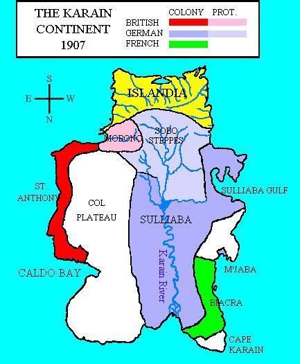
The political divisions portrayed are as of the year 1907, when the semi-continent (excluding Islandia) has been partitioned among several outside powers. A German protectorate controls the southwest, bordering Islandia, and in the extreme northwest is the French Colony of Biacra. Abutting both is a large German Colony administered from the port city of Sulliaba. On the east coast, a British protectorate comprises most of the country of Mobono, governed from the city of the same name, formerly the capital of the native Karain Empire. To the northeast of the British protectorate is the much larger and more prosperous British Crown Colony of St. Anthony, named for and governed from the city of the same name. The remainder of the non-Islandian portion of the semi-continent, about 40% of the whole, is independent. This region comprises primarily interior lands, chiefly the Col Plateau, which is mostly desert. The largest populated area of the independent portion of Karain is the Demiji, located between the Col Plateau and Mobono.
Later political developments in Karain have not been portrayed in the published fiction on Islandia. Presumably after World War I the German controlled regions would have been assigned to other nations as trustee territories. The last glimpse of Karain is from 1969, at which time Islandia is contemplating joining the United Nations; no information about the status of other countries in Karain at that time is provided.
Natural features
Three offshore volcanic islands, Carnia, Kernia, and Ferrin, have been known since 1472. They supply the Islandians with iron, copper, and other minerals.
The largest river in the semi-continent is the Karain River, which runs more or less south-to-north. At its mouth is one of the largest river deltas in the world, rivaling that in Louisiana. The largest city on the delta is Shobo-n-Po, which is independent. There is a great deal of pirate activity near the city. Not counting the arid Col Plateau, the interior of the continent is reputed to be unbroken jungle surrounding the river. The largest lake is at the headwaters of the Karain River, Lake M'Pulo. This in turn is fed by a number of large rivers (the Treacher, the Ono, the Turain, the Kasiholo, the Loborango, the M'Pulo, and the Puchiaihipopolobanjo), which are themselves fed by runoff from the mountain range that separates Islandia from the rest of Karain. The only city of note on lake M'Pulo is Todojil, and to its south and west is the massive Karain Swamp, which forms the upper end of the German Protectorate.
The Karain semi-continent has four distinct watersheds, the largest of which makes up the entire core of the semi-continent itself.
The Karain Watershed
The center of the semi-continent is a massive valley running roughly south to north, and bordered on three sides by mountain chains. Runoff from the mountains flows downhill until it meets Lake M-pulo. To the south, the Karain watershed is bordered by the alpine Islandia Mountains, and meltwater from these provides most of the water to the valley. In the west, the Ono and Matclorn Rivers flow south and east out of the mountains over the Sobo steppes, which eventually merge into the Karain River. As the Karain River flows north, it merges with the Sesipopolo River flowing out of the central Sobo region. A bit further north the Karain merges with the Pachicachipopolobango River which flows north and east out of the eastern Steppes and the Islandia mountains, with its headwaters just north of the Omoa pass. Perhaps thirty miles further north, the Karain meets up with the Kesikolo River bringing meltwaters from Mount Nokono in the east. From there the Karain bends sharply, and enters the large Karain Swamp, where it merges with the Treacher River, which itself originates in the alpine Omoa Pass region.
From there the Karain empties into massive Lake M-pulo. M-pulo is fed by several other large rivers, most notably the Todojl River flowing in from the Tahitikl mountains to the west.
Lake M-polo empties into the northern Karain River, but the elevation of the land in the valley is very slight, so the river meanders through fifteen large bends before it reaches the ocean (presumed to be the Atlantic) 400 miles (640 km) to the south. There are only three settlements of any size along the northern Karain, the entire interior of the continent being essentially one vast, trackless jungle or rainforest. The southernmost of these is Karain Town, which was renamed Wilhelmsburg during the German colonial period. A hundred or so miles south of that is Shobo-n-po, at which point the river breaks up into numerous tributaries in the massive delta. There is a large Pirate Stronghold in the delta, though details about it are lacking.
The Meroma River is a second large river in the Karain Watershed, running for perhaps a hundred miles roughly south-to-north from the northern end of the Col Plateau until it reaches the ocean (again, presumed to be the Atlantic) about a hundred miles east, and a little bit to the north of the Karain.
The Mobono Watershed
To the south and east of the Karain Watershed is the Mobono Watershed, dominated by the Mobono, a comparatively minor river perhaps sixty miles long. It flows down to the east from Mount Nokono, where it meets the city of Mobono at the ocean.
The Eastern Watershed
The region between the western mountains and the ocean is devoid of rivers, with the only one of any consequence being the Tillie River, which flows west from the Omoa pass about 40 miles (64 km) to the ocean, with the city of M-paba at its mouth.
The Islandia Watershed
Islandia is a broad peninsula that is cut off from the remainder of the semi-continent by a large curved chain of alpine mountains. The area is well watered, but most of the rivers are comparatively short.
On the east coast we find the Carran River, the Miltain River, and the Beal River, each named for the dominant towns nearest them. The Niven River is the longest in the eastern half of the country, running more or less southeast from the Frays, a large plateau in the mountains. The Frays also produce several small creeks and streams which eventually merge to form Islandia's central river, the Bannar River, which leads due north to Islandia bay, which then opens into the ocean. Islandia's capital city, "Elanery" (in the local language, but generally translated as simply "The City") is on three islands in the mouth of this river. On the west, the Bannar River also opens into Islandia Bay. East of there, the northern coast is broken by the Helby and Inerria rivers. On the west coast is the Doring River, far and away the longest river in all Islandia, starting out below the Mora Pass atop the Frays, and running roughly southwest through the town of Doring until it breaks up into a delta and meets the ocean. The Lay River, really more of a large stream, runs south and west and joins the delta. north of that lies the Dale and Farrant Rivers.