Local time Friday 8:52 AM | ||
 | ||
Federal subject Karachay-Cherkess Republic Administratively subordinated to town of republic significance of Karachayevsk Administrative center of Karachayevsky District, town of republic significance of Karachayevsk Urban okrug Karachayevsky Urban Okrug Administrative center of Karachayevsky Urban Okrug, Karachayevsky Municipal District Weather 7°C, Wind SE at 11 km/h, 41% Humidity | ||
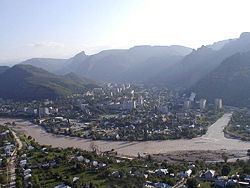
Karachayevsk (Russian: Карача́евск) is a town in the Karachay-Cherkess Republic, Russia, located on the Kuban River in the Caucasus Mountains. Population: 21,483 (2010 Census); 22,113 (2002 Census); 21,582 (1989 Census).
Contents
- Map of Karachaevsk Karachay Cherkessia Russia
- History
- Administrative and municipal status
- Demographics
- References
Map of Karachaevsk, Karachay-Cherkessia, Russia
History
It was founded in 1929 as Georgiyevskoye and was soon renamed after Anastas Mikoyan as Mikoyan-Shakhar. From October 5, 1944 to January 1, 1957, when the Karachays were in exile to the Central Asian deserts, it was part of the Georgian SSR as Klukhori.
The vicinity is rich in early medieval monuments, such as the ruins of Skhimar and the early 10th-century Shoana Church.
Administrative and municipal status
Within the framework of administrative divisions, Karachayevsk serves as the administrative center of Karachayevsky District, even though it is not a part of it. As an administrative division, it is, together with one town (Teberda), three urban-type settlements (Elbrussky, Ordzhonikidzevsky, and the resort settlement of Dombay), and two rural localities (the settlements of Mara-Ayagyy and Malokurganny), incorporated separately as the town of republic significance of Karachayevsk—an administrative unit with the status equal to that of the districts. As a municipal division, the town of republic significance of Karachayevsk is incorporated as Karachayevsky Urban Okrug.
Demographics
In 2002, the population included:
