
Country India District Bageshwar Vehicle registration UK | State Uttarakhand Time zone IST (UTC+5:30) | |
 | ||
Website | ||
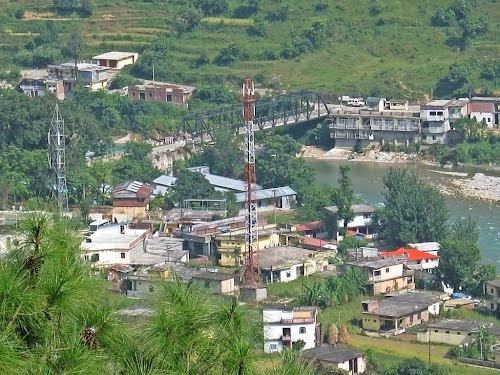
Kapkot or Kapkote (Hindi: कपकोट) is a town in Bageshwar district, Uttarakhand, India. It houses the headquarters of Kapkot Tehsil, the largest administrative subdivision of Bageshwar district. The city is known for being the last bus terminus on the route to Pindari Glacier. Kapkot is located almost 25 km from its district headquarter at Bageshwar.
Contents
- Map of Kapkot Uttarakhand
- History
- Geography
- Demographics
- Government and Politics
- Transport
- Education
- See More
- References
Map of Kapkot, Uttarakhand
History
The area that is now Kapkot was ruled by the Katyuris until the 16th century. Kapkot is first mentioned as a village located in Danpur Pargana of Kumaon District, British India. By the start of the 20th century, The London Missionary Society had a station, with a school and a dispensary at Kapkot. The British system of administration was abolished when India became independent in 1947 and village Kapkot was located in the northern part of tehsil Almora in Almora district, Uttar Pradesh. The tahsil Kapkot was created on September 12, 1997, by transferring 214 villages of tahsil Bageshwar of Almora district.
Geography
Kapkot is located at 29.9379° N, 79.9025° E. It has an average elevation of 101 metres. The city of Kapkot lies on the bank of the river Sarju, which runs to the left of the city. The land in and around Kapkot is utilised largely for agricultural activity, which is fostered by water from the Sarju. The topography is marked by valleys, local depression and high ground.
Kapkot is cold and dry for eight months of the year. Cold winds are experienced during February and March. The hottest months are from March to July. The city experiences a moderate climate from August to October, tempered by heavy rain and thundershowers, and a slightly cooler climate from November to February. Fog and dew are very common, occurring often during the winter season. The city is also situated on a major landslide-prone area.
Demographics
According to the 2011 census of India, the area covered by the Kapkot Village had a population of 2858 with a sex-ratio of 1011 females for every 1,000 males, much above the national and state average of 929 and 963 respectively. A total of 414 were under the age of six, constituting 293 males and 191 females. Scheduled Castes and Scheduled Tribes accounted for 31.39% and 1.12% of the population respectively. The average literacy rate of the city was 81.91%, compared to the national average of 72.99%. The Population is predominantly rural with high concentration of people belonging to Scheduled Castes.
According to the religious census of 2011, Kapkot had 85.8% Hindus, 8.5% Muslims, 5.2% Christians and 0.5% others. Kumaoni is spoken by most, and the standard dialect is the Danpuriya dialect.
Government and Politics
As per constitution of India and Panchyati Raaj Act, Kapkot village is administrated by Sarpanch (Head of Village) who is elected representative of village. The village of Kapkot is represented in the Uttarakhand Legislative Assembly by a member elected from the Kapkot Constituency.
Transport
Kapkot is connected to Bageshwar by Uttarakhand State Highway 37. Another road connects Kapkot to Tejam and further to Thal and Munsiari. Bus services to Bageshwar started in 1955-56.
Education
Industrial training institute was opened in 2007.